Jump to content

Karakert

Coordinates: 40°14′25″N 43°48′35″E / 40.24028°N 43.80972°E / 40.24028; 43.80972
From Wikipedia, the free encyclopedia

This is an old revision of this page, as edited by Bonadea (talk | contribs) at 07:03, 30 April 2019 (Reverted 1 edit by Kivetat (talk): Unsourced addition and completely irrelevant see-also (TW)). The present address (URL) is a permanent link to this revision, which may differ significantly from the current revision.

Karakert
Քարակերտ
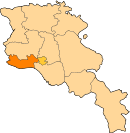
Karakert is located in Armenia
Karakert
Karakert
Coordinates: 40°14′25″N 43°48′35″E / 40.24028°N 43.80972°E / 40.24028; 43.80972
CountryArmenia
Marz (Province)Armavir
Population
 (2008)
 • Total3,707

40°14′25″N 43°48′35″E / 40.24028°N 43.80972°E / 40.24028; 43.80972 Karakert (Armenian: Քարակերտ), formerly known as Karmrashen and Karaburun, is a village in the Armavir Province of Armenia. Population is 4757.

See also

References