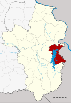
Sirindhorn district
Sirindhorn
สิรินธร | |
|---|---|
 Wat Sirindhorn Wararam Phu Phrao | |
 District location in Ubon Ratchathani Province | |
| Coordinates: 15°12′6″N 105°23′54″E / 15.20167°N 105.39833°E | |
| Country | Thailand |
| Province | Ubon Ratchathani |
| Seat | Nikhom Sang Ton-eng Lam Dom Noi |
| Subdistricts | 6 |
| Mubans | 76 |
| District established | 1992 |
| Area | |
| • Total | 370.0 km2 (142.9 sq mi) |
| Population (2015) | |
| • Total | 52,981 |
| • Density | 130.2/km2 (337/sq mi) |
| Time zone | UTC+7 (ICT) |
| Postal code | 34350 |
| Geocode | 3425 |
Sirindhorn (Template:Lang-th; RTGS: Sirinthon) is a district (amphoe) of Ubon Ratchathani Province, Thailand, established by the Royal Decree Establishing Amphoe Sirindhorn, BE 2534 (1991), coming into force on 4 January 1992. It was named in the honour of Princess Sirindhorn on the occasion of her 36th birthday.
Creation
The district was created effective 3 January 1992 by splitting off tambon Kham Khuean Kaeo from Khong Chiam and the five tambons, Khan Rai, Chong Mek, Nikhom Sang Ton-eng Lam Dom Noi, Non Ko, and Fang Kham, from Phibun Mangsahan.[1]
Geography
Neighboring districts are (from the south clockwise): Buntharik, Phibun Mangsahan and Khong Chiam. To the west across the Mekong river is the Lao province of Champasak.
The Sirindhorn Dam that dams the Dom Noi River is in this district.
There is a border crossing to Laos here—from Chong Mek on the Thai side to Vang Tao on the Lao side, with onward travel typically to Pakxe.

Administration
Central administration
The district is divided into six subdistricts (tambons), which are further subdivided into 76 administrative villages (mubans).
| No. | Name | Thai | Villages | Pop.[2] |
|---|---|---|---|---|
| 1. | Khan Rai | คันไร่ | 16 | 11,483 |
| 2. | Chong Mek | ช่องเม็ก | 13 | 9,301 |
| 3. | Non Ko | โนนก่อ | 14 | 10,613 |
| 4. | Nikhom Sang Ton-eng Lam Dom Noi | นิคมสร้างตนเองลำโดมน้อย | 13 | 7,538 |
| 5. | Fang Kham | ฝางคำ | 4 | 3,588 |
| 6. | Kham Khuean Kaeo | คำเขื่อนแก้ว | 16 | 10,458 |
Local administration
There are two subdistrict municipalities (thesaban tambons) in the district:
- Chong Mek (Thai: เทศบาลตำบลช่องเม็ก) consisting of parts of subdistrict Chong Mek.
- Nikhom Sang Ton-eng Lam Dom Noi (Thai: เทศบาลตำบลนิคมสร้างตนเองลำโดมน้อย) consisting of subdistrict Nikhom Sang Ton-eng Lam Dom Noi.
There are five subdistrict administrative organizations (SAO) in the district:
- Khan Rai (Thai: องค์การบริหารส่วนตำบลคันไร่) consisting of subdistrict Khan Rai.
- Chong Mek (Thai: องค์การบริหารส่วนตำบลช่องเม็ก) consisting of parts of subdistrict Chong Mek.
- Non Ko (Thai: องค์การบริหารส่วนตำบลโนนก่อ) consisting of subdistrict Non Ko.
- Fang Kham (Thai: องค์การบริหารส่วนตำบลฝางคำ) consisting of subdistrict Fang Kham.
- Kham Khuean Kaeo (Thai: องค์การบริหารส่วนตำบลคำเขื่อนแก้ว) consisting of subdistrict Kham Khuean Kaeo.
References
- ^ "พระราชกฤษฎีกาตั้งอำเภอสิรินธร พ.ศ. ๒๕๓๔" (PDF). Royal Gazette (in Thai). 108 (211 ก ฉบับพิเศษ): 29–31. 1991-12-04.
- ^ "Population statistics 2014" (in Thai). Department of Provincial Administration. Retrieved 2015-06-24.
External links
- ubonratchathani.go.th (Thai)
- Amphoe.com on Sirindhorn district (Thai)
