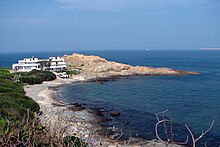
Cape D'Aguilar Marine Reserve

Cape D'Aguilar Marine Reserve (Chinese: 鶴咀海岸保護區) designated in July 1996, is the only Marine Reserve in Hong Kong. It is located at the far south-east corner of Hong Kong Island and covers an area of just 20 hectares mainly between Kau Pei Chau and the rocky coastline.[1] It was designated to protect the rocky shores and the subtidal habitats in the area.
Cape D'Aguilar Marine Reserve is managed by the Agriculture, Fisheries and Conservation Department (AFCD) with on-site assistance from the Swire Institute of Marine Science, a research faculty of the University of Hong Kong.
History

In 1991, the area was designated a Site of Special Scientific Interest (SSSI) by the Government.[2] In 1996, it became the only Marine Reserve in Hong Kong.
Rules in the reserve
Fishing, swimming, diving and collecting organisms are strictly prohibited in the marine reserve[3] and a permit must be obtained from the AFCD before conducting research there.[4]
See also
References
- ^ EPD - Environmental Baseline Report
- ^ "Swire Institute of Marine Science,HKU: Mission". Archived from the original on 2015-03-12. Retrieved 2013-05-14.
- ^ Dept of Ecology and Biodiversity, HKU:Exploring Rocky Stores
- ^ "Visiting Cape d'Aguilar". Archived from the original on 2015-03-12. Retrieved 2013-05-14.
External links
