Rustenburg Local Municipality
Rustenburg Metropolitan
Rustenburg Local Municipality | |
|---|---|
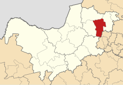
 Location in the North West | |
| Coordinates: 25°40′S 27°20′E / 25.667°S 27.333°E | |
| Country | South Africa |
| Province | North West |
| District | Bojanala Platinum |
| Seat | Rustenburg |
| Wards | 45 |
| Government | |
| • Type | Municipal council |
| • Mayor | Mpho Khunou |
| Area | |
| • Total | 3,423 km2 (1,322 sq mi) |
| Population (2011)[2] | |
| • Total | 549,575 |
| • Density | 160/km2 (420/sq mi) |
| Racial makeup (2011) | |
| • Black African | 88.5% |
| • Coloured | 0.9% |
| • Indian/Asian | 0.8% |
| • White | 9.4% |
| First languages (2011) | |
| • Tswana | 53.9% |
| • Afrikaans | 9.9% |
| • Xhosa | 9.6% |
| • Tsonga | 5.6% |
| • Other | 21% |
| Time zone | UTC+2 (SAST) |
| Municipal code | NW373 |
Rustenburg Metropolitan is a local municipality in Bojanala Platinum District Municipality, North West Province, South Africa.
Rustenburg City is situated at the foot of the Magalies mountain range in the North West province of South Africa. Rustenburg (meaning “town of rest” or “resting place”) was proclaimed a township in 1851. The city of Rustenburg is situated some 112 km northwest, ninety minute drive from both Johannesburg and Pretoria. It is a malaria-free area.
Rustenburg is the fastest growing municipality in South Africa, with the population rising from 387,096 in 2001 to 449,776 in 2007. It is the most populous municipality in the North West province.
Rustenburg is a Dutch name meaning "town (originally castle) of rest".[4]
Main places
The 2001 census divided the municipality into the following main places:[5]
| Place | Code | Area (km2) | Population | Most spoken language |
|---|---|---|---|---|
| Bafokeng | 60301 | 1,040.98 | 132,277 | Tswana |
| Bakwena Ba Magopa | 60302 | 297.74 | 16,049 | Tswana |
| Baphalane | 60303 | 2.85 | 3,399 | Tswana |
| Bapo Ba Ga Mogale | 60304 | 29.41 | 8,412 | Tswana |
| Boitekong | 60305 | 2.15 | 21,547 | Tswana |
| Hartebeesfontein | 60306 | 5.89 | 23,965 | Tswana |
| Magaliesberg Nature Reserve | 60307 | 132.58 | 1,196 | Tswana |
| Mankwe | 60308 | 1.50 | 1,463 | Tswana |
| Meriting | 60309 | 1.88 | 10,711 | Tswana |
| Monakato | 60310 | 3.42 | 7,602 | Tswana |
| Paardekraal Platinum Mine | 60312 | 0.37 | 24 | Xhosa |
| Paardekraal | 60311 | 1.91 | 7,215 | Tswana |
| Phatsima | 60313 | 2.23 | 5,921 | Tswana |
| Rooikoppies | 60314 | 0.46 | 3,670 | Tswana |
| Rustenburg Part 1 | 60315 | 183.39 | 67,196 | Afrikaans |
| Rustenburg Part 3 | 60320 | 2.58 | 4,662 | Tswana |
| Sunrise Park | 60316 | 2.14 | 10,312 | Tswana |
| Tlhabane | 60317 | 5.12 | 31,338 | Tswana |
| Waterval | 60318 | 0.57 | 979 | Afrikaans |
| Remainder of the municipality (Rustenburg Part 2) |
60319 | 1,774.55 | 37,581 | Tswana |
Politics
The municipal council consists of eighty-nine members elected by mixed-member proportional representation. Forty-five councillors are elected by first-past-the-post voting in forty-five wards, while the remaining forty-four are chosen from party lists so that the total number of party representatives is proportional to the number of votes received. In the election of 3 August 2016 no party won a majority on the council. The African National Congress (ANC) narrowly retained control of the municipality with the support of the African Independent Congress (AIC) and the Botho Community Movement (BCM).
The following table shows the results of the election.[6][7]
style="width: 2px; background-color: #006600;" data-sort-value="African National Congress" | style="width: 2px; background-color: #852A2A;" data-sort-value="Economic Freedom Fighters" | style="width: 2px; background-color: #005BA6;" data-sort-value="Democratic Alliance (South Africa)" | style="width: 2px; background-color: lightgrey;" data-sort-value="Forum 4 Service Delivery" | style="width: 2px; background-color: #ffb543;" data-sort-value="African Independent Congress" | style="width: 2px; background-color: #EC8713;" data-sort-value="Freedom Front Plus" | style="width: 2px; background-color: #FFB300;" data-sort-value="United Democratic Movement" | style="width: 2px; background-color: lightgrey;" data-sort-value="Botho Community Movement" || Party | Votes | Seats | ||||||
|---|---|---|---|---|---|---|---|---|
| Ward | List | Total | % | Ward | List | Total | ||
| ANC | 71,149 | 69,868 | 141,017 | 48.6 | 34 | 9 | 43 | |
| EFF | 39,455 | 38,273 | 77,728 | 26.8 | 5 | 19 | 24 | |
| DA | 23,446 | 23,013 | 46,459 | 16.0 | 6 | 8 | 14 | |
| Forum 4 Service Delivery | 6,312 | 5,467 | 11,779 | 4.1 | 0 | 4 | 4 | |
| AIC | 1,036 | 2,919 | 3,955 | 1.4 | 0 | 1 | 1 | |
| VF+ | 1,973 | 1,852 | 3,825 | 1.3 | 0 | 1 | 1 | |
| UDM | 529 | 974 | 1,503 | 0.5 | 0 | 1 | 1 | |
| Botho Community Movement | 630 | 565 | 1,195 | 0.4 | 0 | 1 | 1 | |
| Others | 1,187 | 1,810 | 2,997 | 1.0 | 0 | 0 | 0 | |
| Total | 145,717 | 144,741 | 290,458 | 100.0 | 45 | 44 | 89 | |
| Spoilt votes | 2,731 | 3,171 | 5,902 | |||||
References
- ^ "Contact list: Executive Mayors". Government Communication & Information System. Archived from the original on 14 July 2010. Retrieved 22 February 2012.
- ^ a b "Statistics by place". Statistics South Africa. Retrieved 27 September 2015.
- ^ "Statistics by place". Statistics South Africa. Retrieved 27 September 2015.
- ^ South African Languages - Place names
- ^ Lookup Tables - Statistics South Africa
- ^ "Results Summary – All Ballots: Rustenburg" (PDF). Independent Electoral Commission. Retrieved 22 April 2017.
- ^ "Seat Calculation Detail: Rustenburg" (PDF). Independent Electoral Commission. Retrieved 22 April 2017.


