
Arish Mell

Arish Mell is a small embayment and beach between Mupe and Worbarrow Bays in Dorset, England. It is part of the Jurassic Coast.
Geography
Location
Arish Mell lies about a mile due south of Lulworth Castle and East Lulworth, both of which were established at the head of the valley that runs down to the area of the bay and may have been the original direct route to the coast for the estate.
Access
Arish Mell is relatively inaccessible because it is within the Lulworth Ranges, an Army tank firing range, and although the Range Walks are open at most weekends and public holidays, there is no public access to the beach and cliffs. The South West Coast Path runs past the bay just to the north.
Geology
This section needs expansion. You can help by adding to it. (May 2013) |
Arish Mell forms a break in the line of chalk hills that form the Purbeck Ridge.
See also
History
Arish Mell was the site of a series discharges pipes carrying effluent from the Winfrith Nuclear Power Station into the sea.
References
Gallery
-
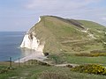 Arish Mell from the east.
 -
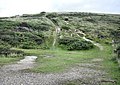 Behind Arish Mell


50°37′19″N 2°12′25″W / 50.622°N 2.207°W
This Dorset location article is a stub. You can help Wikipedia by expanding it. |