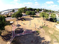
Giv'at Ko'ah
Giv'at Ko'ah
| |
|---|---|
 A playground in Giv'at Ko'ah. | |
| Coordinates: 32°1′48″N 34°56′9.96″E / 32.03000°N 34.9361000°E | |
| Grid position | 144/159 PAL |
| Country | Israel |
| District | Central |
| Council | Hevel Modi'in |
| Affiliation | Moshavim Movement |
| Founded | 1950 |
| Founded by | Yemenite immigrants |
| Population (2022)[1] | 865 |
Giv'at Ko'ah (Template:Lang-he-n, lit. Hill of the Twenty Eight or Strength Hill) is a moshav in central Israel. Located to the south of Petah Tikva, it falls under the jurisdiction of Hevel Modi'in Regional Council. In 2022 it had a population of 865.[1]
History

The village was founded on 2 July 1950 by immigrants from Yemen.[3] It was named for the 28 soldiers (כ"ח is the Hebrew numerals for 28) from the Alexandroni Brigade who died in fighting at Qula during the 1948 Arab-Israeli War.[4] A monument to these soldiers is located on a hill about 3 km east of the village.[5]
Giv'at Ko'ah, along with Tirat Yehuda and Bareket, is located near the former Palestinian village of village of al-Tira, which was destroyed during the 1948 Arab–Israeli War.[6]
Giv'at Ko'ah was also home to a group of Cochin Jews who emigrated from the village of Chendamangalam, India. In 2010, the Nehemiah Mott Synagogue was built in Giv'at Ko'ah, named after a Yemenite kabbalist revered by this community.[7]
References
- ^ a b "Regional Statistics". Israel Central Bureau of Statistics. Retrieved 21 March 2024.
- ^ Alexandroni Cycling and Hiking Trail in Elad Forest Jewish National Fund
- ^ Mathilde A. Tagger; Yitzchak Kerem (2006). Guidebook for Sephardic and Oriental Genealogical Sources in Israel. Avotaynu.
- ^ Talmi, Ephraim; Talmi, Menahem (September 1966). All the Land - A Geographical Lexicon of Israel (in Hebrew). Amichai Publishers. p. 117.
- ^ History Giv'at Ko'ah
- ^ Khalidi, Walid (1992). All That Remains: The Palestinian Villages Occupied and Depopulated by Israel in 1948. Washington D.C.: Institute for Palestine Studies. p. 418. ISBN 0-88728-224-5.
- ^ Shalva Weil. "Where are Cochin Jews today?". cochinsyn.com.

