Bolívar Partido
Appearance
Bolívar
Partido de Bolívar | |
|---|---|
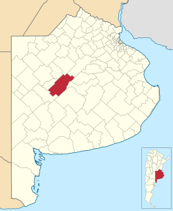
 Location of Bolívar Partido in Buenos Aires Province | |
| Coordinates: 36°14′S 61°07′W / 36.233°S 61.117°W | |
| Country | Argentina |
| Established | March 2, 1938 |
| Seat | San Carlos de Bolívar |
| Government | |
| • Mayor | Jose "Bali" Bucca |
| Area | |
| • Total | 5,027 km2 (1,941 sq mi) |
| Population | |
| • Total | 32,442 |
| • Density | 6.5/km2 (17/sq mi) |
| Demonym | bolivarense |
| Postal Code | B6550 |
| IFAM | |
| Area Code | 02314 |
| Website | http://www.bolivar.gov.ar[permanent dead link] |
Bolívar Partido is a partido (second level administrative subdivision) located in central Buenos Aires Province, Argentina.
The partido has 5,027 km² (1,941 sq mi) and a population of 32,442 (2001 census [INDEC]), and its capital is San Carlos de Bolívar.
Settlements
- San Carlos de Bolívar
- Hale
- Juan F. Ibarra
- Mariano Unzué
- Paula (Est. La Paula)
- Pirovano
- Villa Lynch Pueyrredón
- Vallimanca
- Urdampilleta
External links
- (in Spanish)Official site of Gobierno Municipal del Partido de Bolívar
- (in Spanish)Tourism Bolívar
- (in Spanish) Federal website
- (in Spanish) La Mañana, Bolívar newspaper
