Dainava (Kaunas)
Appearance
You can help expand this article with text translated from the corresponding article in Lithuanian. (January 2013) Click [show] for important translation instructions.
|
Dainava | |
|---|---|
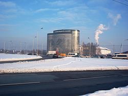
 1000 Lt building | |
| Country | |
| County | Kaunas County |
| Municipality | Kaunas city municipality |
| Area | |
| • Total | 7.28 km2 (2.81 sq mi) |
| Population (2006) | |
| • Total | 70,000 |
| • Density | 9,600/km2 (25,000/sq mi) |
| Time zone | UTC+2 (EET) |
| • Summer (DST) | UTC+3 (EEST) |

Dainava is a fairly new neighbourhood (built in 1963, initially as a microdistrict) located in the north of center of Kaunas, the second largest city of Lithuania. It has an elderate status. The borough borders Kaunas Free Economic Zone in the north, Petrašiūnai in the east, Gričiupis in the south as well as Žaliakalnis and Eiguliai in the west.
In the elderate there is an old Jewish cemetery, Lithuanian Zoo, many faculties of Kaunas University of Technology, Friendship Park (Lithuanian: Draugystės parkas) started in 1973. The neighbourhood was built in a typical soviet fashion. It is one of the largest elderates in Kaunas with over 70,000 inhabitants as of 2006 despite its small area of only 7.28 square kilometres (2.81 sq mi).
External links
- (in Lithuanian) Official site
