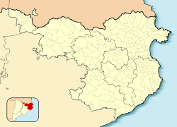
Colera
Appearance
Colera | |
|---|---|
 | |
| Coordinates: 42°24′N 3°9′E / 42.400°N 3.150°E | |
| Country | |
| Community | |
| Province | |
| Comarca | |
| Government | |
| • Mayor | Lluís Bosch Rebarter (2015)[1] |
| Area | |
| • Total | 24.4 km2 (9.4 sq mi) |
| Population (2018)[3] | |
| • Total | 465 |
| • Density | 19/km2 (49/sq mi) |
| Website | www |
Colera is a municipality in the comarca of Alt Empordà, Girona, Catalonia, Spain, on the Costa Brava. It is a village on the coast with an economy primarily based on tourism. It has several beaches within its vicinity including: Garbet, Burro, Atzuzenes, Portes, Morts la de'n Goixa, and Rovellada.
References
- ^ "Ajuntament de Colera". Generalitat of Catalonia. Retrieved 2015-11-13.
- ^ "El municipi en xifres: Colera". Statistical Institute of Catalonia. Retrieved 2015-11-23.
- ^ Municipal Register of Spain 2018. National Statistics Institute.
External links
- Government data pages (in Catalan)


