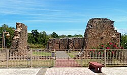
Hermitage of San Antonio de Padua de la Tuna
Hermitage of San Antonio de Padua de la Tuna | |
 The hermitage in 2017 | |
| Location | Ermita Street La Tuna sector Highway 2, km 106.1 Barrio Coto Isabela, Puerto Rico[1] |
|---|---|
| Coordinates | 18°28′43″N 66°57′48″W / 18.478613°N 66.96339°W |
| Built | 1730 |
| NRHP reference No. | 83004193 |
| Added to NRHP | December 2, 1983 |
The Hermitage of San Antonio de Padua de la Tuna (Spanish: Ermita de San Antonio de Padua de la Tuna) near Isabela, Puerto Rico dates from 1730. It comprises the ruins of a village church that was abandoned in the early 19th century when the community, with the permission of Governor Salvador Meléndez, moved to a more favorable location nearer the coast, which became the town of Isabela, founded in 1819.[2][3]
The hermitage was listed on the U.S. National Register of Historic Places in 1983.[4]
See also
References
- ^ "Contáctenos", Corporación Mabodamaca, Inc., n.d., archived from the original on January 26, 2016, retrieved January 25, 2016.
- ^ Morales Parés, Armando (August 24, 1983), National Register of Historic Places Inventory — Nomination Form: Hermitage of San Antonio de Padua de la Tuna (redacted PDF), retrieved January 25, 2016.
- ^ Isabela, Puerto Rico Encyclopedia, 2005-2011.
- ^ National Park Service (December 12, 1983), Weekly announcement of National Register of Historic Places actions (PDF), p. 195, retrieved January 25, 2016.
External links
- Corporación Mabodamaca, owns, protects, researches, and interprets the ermita (in Spanish)
- Summary sheet from the Puerto Rico State Historic Preservation Office (in Spanish)
- San Antonio de la Tuna – The Original Town of Isabela, Puerto Rico Day Trips travel guide

