
Beaver Brook Falls Wayside
| Beaver Brook Falls Wayside | |
|---|---|
 | |
 | |
| Location | 432 Route 145, Colebrook Coos County, New Hampshire |
| Coordinates | 44°55′09″N 71°27′46″W / 44.9191°N 71.4628°W |
| Area | 7.3 acres (3.0 ha) |
| Operated by | New Hampshire Division of Parks and Recreation |
| Website | Beaver Brook Falls Wayside |
Beaver Brook Falls Wayside is a 7.3-acre (3.0 ha) park in Colebrook, New Hampshire, along Route 145. It features a roadside view of the scenic 80 ft (24 m) Beaver Brook Falls.[1][2] Picnic tables, restroom facilities and a small picnic shelter are available.
Photos
-
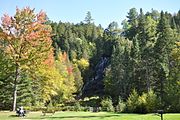 Wayside park in autumn 2016
 -
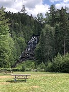
 Open area with picnic tables and rain shelter, autumn 2016


-
 The falls in autumn 2016
 -
 The falls in August 2019


References
Wikimedia Commons has media related to Beaver Brook Falls Wayside Park.
- ^ "Beaver Brook Falls". New England Waterfalls. Retrieved 18 February 2017.
- ^ "Beaver Brook Falls". Waterfalls of the Northeast United States. Retrieved 18 February 2017.
This New Hampshire state location article is a stub. You can help Wikipedia by expanding it. |