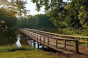
Great River Road State Park
| Great River Road State Park | |
|---|---|
 | |
| Location | Rosedale, Bolivar, Mississippi, United States |
| Coordinates | 33°50′28″N 91°02′28″W / 33.84111°N 91.04111°W |
| Established | Unspecified |
| Named for | The Great River Road |
| Governing body | City of Rosedale |
| Website | Great River Road State Park |
Great River Road State Park is a public recreation area in the U.S. state of Mississippi located off Mississippi Highway 1 in the southwest corner of the city of Rosedale.[1]
Activities and amenities
The state park features boating and fishing on 25-acre (10 ha) Perry Martin Lake[2] as well as picnicking facilities and a playground. The park's 75-foot (23 m) lookout tower which offered views of the Mississippi River was taken down following the damaging floods of 2011.[1]
References
- ^ a b "Great River Road State Park". Parks and Destinations. Mississippi Department of Wildlife, Fisheries, and Parks. Retrieved July 9, 2014.
- ^ "Perry Martin Lake" (PDF). Delta Wildlife, Inc. Retrieved December 8, 2016.
External links
Wikimedia Commons has media related to Great River Road State Park.
- Great River Road State Park Mississippi Department of Wildlife, Fisheries, and Parks

