
Fouchères, Aube
You can help expand this article with text translated from the corresponding article in French. (December 2008) Click [show] for important translation instructions.
|
Fouchères | |
|---|---|
 The church square in Fouchères | |
 Coat of arms | |
Location of Fouchères  | |
 Fouchères  Fouchères | |
| Coordinates: 48°08′59″N 4°15′56″E / 48.1497°N 4.2656°E | |
| Country | France |
| Region | Grand Est |
| Department | Aube |
| Arrondissement | Troyes |
| Canton | Bar-sur-Seine |
| Government | |
| • Mayor (2008–2014) | Jean-Pierre Thorey |
| Area 1 | 8.58 km2 (3.31 sq mi) |
| Population (2021)[1] | 516 |
| • Density | 60/km2 (160/sq mi) |
| Time zone | UTC+01:00 (CET) |
| • Summer (DST) | UTC+02:00 (CEST) |
| INSEE/Postal code | 10158 /10260 |
| Elevation | 130–192 m (427–630 ft) (avg. 138 m or 453 ft) |
| 1 French Land Register data, which excludes lakes, ponds, glaciers > 1 km2 (0.386 sq mi or 247 acres) and river estuaries. | |
Fouchères is a commune in the Aube department in north-central France located at the river Seine.
Population
| Year | Pop. | ±% |
|---|---|---|
| 1962 | 320 | — |
| 1968 | 339 | +5.9% |
| 1975 | 321 | −5.3% |
| 1982 | 394 | +22.7% |
| 1990 | 422 | +7.1% |
| 1999 | 450 | +6.6% |
| 2008 | 494 | +9.8% |
See also
References
- ^ "Populations légales 2021". The National Institute of Statistics and Economic Studies. 28 December 2023.
-
 The Seine River and the bridge of Fouchères
 -
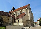 Nativity of the Blessed Virgin Mary Church
 -
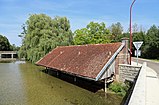 The wash house (lavoir)
 -
 War memorial


Wikimedia Commons has media related to Fouchères, Aube.
| Authority control databases: National |
|---|
This Aube geographical article is a stub. You can help Wikipedia by expanding it. |