Leuhan
Appearance
Leuhan
Leuc'han | |
|---|---|
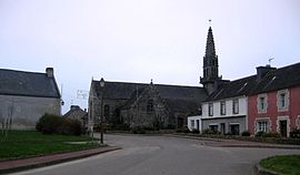
 The parish church of Saint-Théleau and surrounding buildings | |
| Coordinates: 48°06′00″N 3°46′59″W / 48.1000°N 3.7831°W | |
| Country | France |
| Region | Brittany |
| Department | Finistère |
| Arrondissement | Châteaulin |
| Canton | Briec |
| Intercommunality | Haute Cornouaille |
| Government | |
| • Mayor (2014–2020) | André Loussouarn |
| Area 1 | 32.75 km2 (12.64 sq mi) |
| Population (2021)[1] | 827 |
| • Density | 25/km2 (65/sq mi) |
| Time zone | UTC+01:00 (CET) |
| • Summer (DST) | UTC+02:00 (CEST) |
| INSEE/Postal code | 29125 /29390 |
| Elevation | 97–246 m (318–807 ft) |
| 1 French Land Register data, which excludes lakes, ponds, glaciers > 1 km2 (0.386 sq mi or 247 acres) and river estuaries. | |
Leuhan (Leuc'han in Breton) is a commune in the Finistère department of Brittany in north-western France.
Population
Inhabitants of Leuhan are called in French Leuhannais.
| Year | 1793 | 1806 | 1821 | 1831 | 1836 | 1841 | 1846 | 1851 | 1856 | 1861 |
|---|---|---|---|---|---|---|---|---|---|---|
| Population | 1219 | 1130 | 1216 | 1358 | 1488 | 1418 | 1545 | 1524 | 1427 | 1461 |
| Year | 1866 | 1872 | 1876 | 1881 | 1886 | 1891 | 1896 | 1901 | 1906 | 1911 |
|---|---|---|---|---|---|---|---|---|---|---|
| Population | 1533 | 1561 | 1616 | 1640 | 1722 | 1682 | 1764 | 1855 | 1912 | 1933 |
| Year | 1921 | 1926 | 1931 | 1936 | 1946 | 1954 | 1962 | 1968 | 1975 | 1982 |
|---|---|---|---|---|---|---|---|---|---|---|
| Population | 1825 | 1760 | 1667 | 1606 | 1554 | 1529 | 1430 | 1281 | 1043 | 932 |
| Year | 1990 | 1999 | 2008 |
|---|---|---|---|
| Population | 794 | 754 | 781 |
See also
References
- ^ "Populations légales 2021" (in French). The National Institute of Statistics and Economic Studies. 28 December 2023.
- Mayors of Finistère Association (in French);
External links
Wikimedia Commons has media related to Leuhan.
- Official website (in French)
- French Ministry of Culture list for Leuhan (in French)


