
Meurville
You can help expand this article with text translated from the corresponding article in French. (December 2008) Click [show] for important translation instructions.
|
Meurville | |
|---|---|
 The town hall in Meurville | |
Location of Meurville  | |
 Meurville  Meurville | |
| Coordinates: 48°12′11″N 4°37′28″E / 48.2031°N 4.6244°E | |
| Country | France |
| Region | Grand Est |
| Department | Aube |
| Arrondissement | Bar-sur-Aube |
| Canton | Bar-sur-Aube |
| Intercommunality | Région de Bar-sur-Aube |
| Government | |
| • Mayor (2008–2014) | Lydie Carlier |
| Area 1 | 16.35 km2 (6.31 sq mi) |
| Population (2021)[1] | 155 |
| • Density | 9.5/km2 (25/sq mi) |
| Time zone | UTC+01:00 (CET) |
| • Summer (DST) | UTC+02:00 (CEST) |
| INSEE/Postal code | 10242 /10200 |
| Elevation | 200 m (660 ft) |
| 1 French Land Register data, which excludes lakes, ponds, glaciers > 1 km2 (0.386 sq mi or 247 acres) and river estuaries. | |
Meurville is a commune in the Aube department in north-central France.
Population
| Year | Pop. | ±% |
|---|---|---|
| 1962 | 195 | — |
| 1968 | 202 | +3.6% |
| 1975 | 180 | −10.9% |
| 1982 | 187 | +3.9% |
| 1990 | 204 | +9.1% |
| 1999 | 177 | −13.2% |
| 2008 | 179 | +1.1% |
See also
References
- ^ "Populations légales 2021". The National Institute of Statistics and Economic Studies. 28 December 2023.
-
 The Rue Haute in Meurville
 -
 Saint-Benoît church
 -
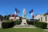 War memorial


Wikimedia Commons has media related to Meurville.
| Authority control databases: National |
|---|
This Aube geographical article is a stub. You can help Wikipedia by expanding it. |