Kai Kecil
Appearance
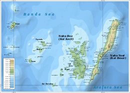
 The Kai Islands. Kai Kecil is west of Kai Besar in the east. | |
| Geography | |
|---|---|
| Location | Southeast Asia |
| Coordinates | 5°45′S 132°40′E / 5.750°S 132.667°E |
| Archipelago | Kai Islands |
| Administration | |
Indonesia | |
| Province | Maluku |
| Additional information | |
| Time zone | |
Kai Kecil (Little Kai Island) is a part of the Kai Islands group of the Maluku Islands, Indonesia. Its area is 399 km2 (154 sq mi). The other main island in the group is Kai Besar (Great Kai Island). It contains the town of Tual.


