
Matamata College
| Matamata College | |
|---|---|
| Address | |
 | |
Firth St, Matamata | |
| Coordinates | 37°49′02″S 175°46′12″E / 37.8173°S 175.7699°E |
| Information | |
| Type | Co-ed state secondary, year 9-13 |
| Motto | Quality Education for all |
| Established | 1918 |
| Ministry of Education Institution no. | 124 |
| Principal | Alan Munro |
| School roll | 781[1] (February 2024) |
| Socio-economic decile | 6N[2] |
| Website | matamatacollege.school.nz |
Matamata College is a state coeducational secondary school located in Matamata, New Zealand.
History
The college was declared open on 11 February 1924 by the Minister for Education, James Parr.[3]
Notable alumni
- Nicola Browne – cricketer
- Judith Collins – politician
- Shane Dye – jockey
- Lyn Grime (born 1962), Olympic hurdler[4]
- Julie Hawkes -- squash player
- Craig Innes – rugby union and rugby league player
- Brendon Leonard – rugby union player
- Richard Nunns – Māori traditional instrumentalist of Pākehā heritage
- Anne Taylor – netball player
- Murray Taylor – rugby union player
- Warwick Taylor – rugby union player
- Casey Williams – netball player
Old images of the school
-
 Aerial view of Matamata College in the 1940s
 -
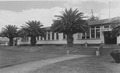 Front of Matamata College in the 1950s


References
- ^ "New Zealand Schools Directory". New Zealand Ministry of Education. Retrieved 14 March 2024.
- ^ "Decile Change 2014 to 2015 for State & State Integrated Schools". Ministry of Education. Retrieved 12 February 2015.
- ^ "New Building at Matamata - Opening by Minister". The New Zealand Herald. 11 February 1924. p. 9.
- ^ "Lynnette O'Connor (Massey)". Matamata College. Retrieved 8 October 2017.
External links
This New Zealand school-related article is a stub. You can help Wikipedia by expanding it. |