Unguja South Region
Appearance
6°16′S 39°25′E / 6.267°S 39.417°E
Unguja South Region
Mkoa wa Unguja Kusini (Swahili) | |
|---|---|
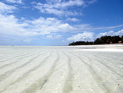
 Paje beach | |
 Location in Tanzania | |
| Country | Tanzania |
| Zone | Zanzibar |
| Capital | Koani |
| Government | |
| • Regional Commissioner | Ayoub Mohammed Mahmoud |
| Area | |
| • Total | 854 km2 (330 sq mi) |
| Population (2012) | |
| • Total | 115,588 |
| • Density | 140/km2 (350/sq mi) |
| Time zone | UTC+3 (EAT) |
| Postcode | 72xxx |
| Area code | 024 |
| HDI (2018) | 0.612[1] medium · 4th |
| Website | ikuluzanzibar |
Unguja South Region is one of the 31 regions of Tanzania. Located on the island of Zanzibar, the town of Koani serves as the region's capital. As of 2002[update], the population was 94,504.[2]
Administrative divisions
Districts
The region is administratively divided into two districts:
| Districts of Unguja South Region | ||
|---|---|---|
| Map | District | Population (2012) |

|
Kati District | 76,346 |
| Kusini District | 39,242 | |
| Total | 115,588 | |
Constituencies
For parliamentary elections, Tanzania is divided into constituencies. As of the 2010 elections Zanzibar Central/South Region had five constituencies:[3]
- Chwaka Constituency
- Koani Constituency
- Makunduchi Constituency
- Muyuni Constituency
- Uzini Constituency
References
- ^ "Sub-national HDI - Area Database - Global Data Lab". hdi.globaldatalab.org. Retrieved 2020-02-26.
- ^ "2002 Population and Housing General Report: South Unguja". Archived from the original on 18 March 2004.
- ^ "Organisations located in Zanzibar South Region - Tanzania". African Development Information.
External links
Wikimedia Commons has media related to Unguja Central South Region.
