Lingwala
Appearance
Lingwala
Commune de Lingwala | |
|---|---|
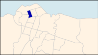
 Lingwala on a map of Kinshasa communes | |
 Kinshasa city-province on a map of the DRC | |
| Coordinates: 04°19′13″S 15°17′54″E / 4.32028°S 15.29833°E[1] | |
| Country | Democratic Republic of the Congo |
| Province | Kinshasa |
| District | Lukunga |
| Area | |
| • Total | 2.88 km2 (1.11 sq mi) |
| Population (2004 est.) | |
| • Total | 94,635 |
| • Density | 33,000/km2 (85,000/sq mi) |
Lingwala is a municipality (commune) in the Lukunga district of Kinshasa, the capital city of the Democratic Republic of the Congo.[2]
It is situated in northern Kinshasa, south of Gombe and Boulevard du 30 Juin.
Demographics
| Year | 1967 | 1970 | 1984 | 2003 | 2004 |
|---|---|---|---|---|---|
| Population | 37,240 | 46,209 | 49,173 | 91,520 | 94,635 |
References
- ^ "Lingwala, Kinshasa, Democratic Republic of the Congo". Google Maps. Retrieved 20 August 2011.
- ^ "Géographie de Kinshasa (Geography of Kinshasa)" (in French). Ville de Kinshasa (City of Kinshasa). Archived from the original on 23 July 2012. Retrieved 20 August 2011.
See also
Wikimedia Commons has media related to Lingwala.
