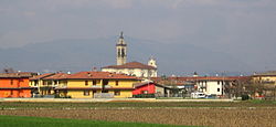
Calcinate
Calcinate | |
|---|---|
| Comune di Calcinate | |
 Calcinate | |
| Coordinates: 45°37′N 9°48′E / 45.617°N 9.800°E | |
| Country | Italy |
| Region | Lombardy |
| Province | Bergamo (BG) |
| Government | |
| • Mayor | Flaminio Tisi |
| Area | |
| • Total | 14 km2 (5 sq mi) |
| Elevation | 186 m (610 ft) |
| Population (Dec. 2004)[2] | |
| • Total | 5,273 |
| • Density | 380/km2 (980/sq mi) |
| Demonym | Calcinatesi |
| Time zone | UTC+1 (CET) |
| • Summer (DST) | UTC+2 (CEST) |
| Postal code | 24050 |
| Dialing code | 035 |
| Patron saint | Sts. Peter and Paul |
| Saint day | June 29 |
Calcinate (Bergamasque: Calsinàt) is a town and comune in the province of Bergamo, Lombardy, Italy. Its economy is mostly based on industry.[citation needed]
History
The origin of the town are Gaulish and Roman, though it is first mentioned in a document from 1148. It was conquered by the Republic of Venice in the 15th century, and remained to it until 1797. In that period it became a flourishing agricultural centre.
Main sights
- Santa Maria Assunta - baroque parish church
- San Martino (c. 14th century) - romanesque church
Notable people
- Manolo Gabbiadini (born 1991), footballer for U.C. Sampdoria in Italy.
- Andrea Belotti (born 1993), footballer for Torino F.C.
References
- ^ "Superficie di Comuni Province e Regioni italiane al 9 ottobre 2011". Italian National Institute of Statistics. Retrieved 16 March 2019.
- ^ All demographics and other statistics: Italian statistical institute Istat.


