
Plombières
This article needs additional citations for verification. (May 2015) |
Plombières
| |
|---|---|
 Place Communale | |
Location of Plombières  | |
 Plombières Location in Belgium
Location of Plombières in the province of Liège  | |
| Coordinates: 50°44′N 05°57′E / 50.733°N 5.950°E | |
| Country | |
| Community | French Community |
| Region | Wallonia |
| Province | Liège |
| Arrondissement | Verviers |
| Government | |
| • Mayor | Thierry Wimmer |
| Area | |
| • Total | 53.17 km2 (20.53 sq mi) |
| Population (2018-01-01)[1] | |
| • Total | 10,401 |
| • Density | 200/km2 (510/sq mi) |
| Postal codes | 4850-4852 |
| NIS code | 63088 |
| Area codes | 087 |
| Website | www.plombieres.be |
Plombières (German: Bleyberg or Bleiberg, Dutch: Blieberg) is a Walloon municipality located in the Belgian province of Liège. On January 1, 2006, Plombières had a total population of 9,672. The total area is 53.17 km² which gives a population density of 182 inhabitants per km².
The municipality Plombières consists of the villages Gemmenich, Hombourg, Montzen, Moresnet, and Sippenaeken.
The local language is Low Dietsch, a bridge dialect between East Limburgish and Ripuarian.
Gallery
-
 Sippenaeken, view to the village
 -
 Beusdael Castle in Sippenaeken
 -
 Gemmenich street
 -
 Gemmenich, church Saint-Hubert
 -
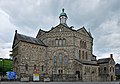 Notre-Dame de l'Assomption church
 -
 German border


.jpg)
.jpg)
See also
References
- ^ "Wettelijke Bevolking per gemeente op 1 januari 2018". Statbel. Retrieved 9 March 2019.
External links
 Media related to Plombières at Wikimedia Commons
Places adjacent to Plombières | ||||||||||||||||
|---|---|---|---|---|---|---|---|---|---|---|---|---|---|---|---|---|
| ||||||||||||||||
Municipalities in the province of Liège, Wallonia | ||
|---|---|---|
| Huy |  | |
| Liège | ||
| Verviers | ||
| Waremme | ||
| ||
This Liège Province location article is a stub. You can help Wikipedia by expanding it. |