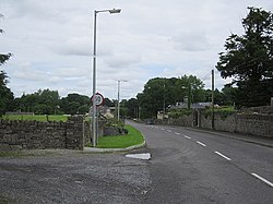
Street, County Westmeath

Coordinates: 53°40′55″N 7°29′24″W / 53.682°N 7.490°W / 53.682; -7.490
From Wikipedia, the free encyclopedia

This is an old revision of this page, as edited by Guliolopez (talk | contribs) at 15:42, 18 March 2020 (Remove uncited (and highly dubious) population number. (I dunno what area you'd have to include to get anywhere near that number. But it would be an area that far exceeded the scope of this article. The entire surrounding ED doesn't even have 270 people living in it, so dunno where this could possible come from. Uncited anyway).). The present address (URL) is a permanent link to this revision, which may differ significantly from the current revision.

Streete
Sráid / an tSráid
Village
Main street
Main street
Streete is located in Ireland
Streete
Streete
Location in Ireland
Coordinates: 53°40′55″N 7°29′24″W / 53.682°N 7.490°W / 53.682; -7.490
CountryIreland
ProvinceLeinster
CountyCounty Westmeath
Elevation
66 m (217 ft)
Time zoneUTC+0 (WET)
 • Summer (DST)UTC-1 (IST (WEST))
Irish Grid ReferenceN340721
Websitewww.westmeathcoco.ie

Street or Streete (Irish: Sráid / an tSráid) is a village and parish in County Westmeath, Ireland. It lies on the regional road between Lismacaffery and Rathowen. Its Irish name was historically anglicised as Straid and Strade.

See also

Shop in the former village institute