
Faro, North Carolina
Faro, North Carolina | |
|---|---|
 Faro, North Carolina  Faro, North Carolina | |
| Coordinates: 35°30′42″N 77°50′38″W / 35.51167°N 77.84389°W | |
| Country | United States |
| State | North Carolina |
| County | Wayne |
| Elevation | 121 ft (37 m) |
| Time zone | UTC-5 (Eastern (EST)) |
| • Summer (DST) | UTC-4 (EDT) |
| Area code(s) | 919 & 984 |
| GNIS feature ID | 1010605[1] |
Faro is an unincorporated community in Wayne County, North Carolina, United States.[1]
1961 Goldsboro B-52 crash
In Faro—12 miles (19 km) north of Seymour Johnson Air Force Base—two hydrogen bombs dropped during the 1961 Goldsboro B-52 crash[2] as the aircraft broke up in flight.[3] The crash site is 1.5 miles (2.4 km) southwest of Faro on Big Daddy's Road.[4]
-
 Thermonuclear bomb resting in a field in Faro
 -
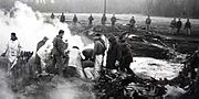 Explosive ordnance disposal personnel work to recover the buried thermonuclear bomb that fell into a field in Faro

Notes
- ^ a b "Faro, North Carolina". Geographic Names Information System. United States Geological Survey, United States Department of the Interior.
- ^ "Atom bomb nearly exploded over North Carolina in 1961 secret documents reveal". Telegraph (UK). Retrieved 2013-09-22.
- ^ Michael Mechanic (August 2013). "A Sneak Peek at Eric Schlosser's Terrifying New Book on Nuclear Weapons". Mother Jones. Retrieved 2013-09-22.
- ^ "Faro, North Carolina". Ibiblio. Retrieved 2013-09-22.
Municipalities and communities of Wayne County, North Carolina, United States | ||
|---|---|---|
| City | 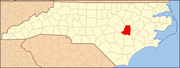 | |
| Towns | ||
| Village | ||
| CDPs | ||
| Other communities | ||
| Footnotes | ‡This populated place also has portions in an adjacent county or counties | |