Llanelly
This article includes a list of general references, but it lacks sufficient corresponding inline citations. (December 2013) |
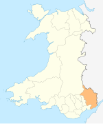
Llanelly (Welsh: Llanelli) is the name of a parish and coterminous community in the principal area of Monmouthshire, within the historic boundaries of Brecknockshire, south-east Wales. It roughly covers the area of the Clydach Gorge. The population of the parish and ward at the 2011 census was 3,899.[1]
Location
The parish encompasses the area surrounding the Clydach Gorge, west of Abergavenny, east of Brynmawr and south of Crickhowell. The Church of St Elli [1] has its own page.
Settlements
Llanelly Hill, Blackrock, Clydach, Maesygwartha and Gilwern are the main settlements in the parish. Llanelly Hill occupies the north-west hilltop of the Clydach Gorge. It developed as a result of coal mining and limestone quarrying for the nearby ironworks including Clydach ironworks and Ebbw Vale ironworks.
Blackrock and Clydach North (also referred to as Cheltenham) both built up along the turnpike road that ran on the north side of the river between Govilon and Merthyr Tydfil. Clydach South developed on the south side of the river above the ironworks, climbing the north-west slopes towards Llanelly Hill.
Gilwern is located at the mouth of the River Clydach, where it meets the river Usk. Maesygwartha lies between Clydach and Gilwern along one of the many tram roads in the gorge.
History
The population in 1841 was 6,846.[2] About 500 men were employed in the collieries. The town was connected by a canal and tram-road to Kidwelly.
The parish is part of the principal area of Monmouthshire. Before local government reorganisation in 1996, it was in the district of Blaenau Gwent, but the electors overwhelmingly voted to be transferred out. The Brecon Beacons National Park [2] encompasses the parish and the surrounding area.
Governance
The electoral ward of Llanelly Hill is coterminous with the Llanelly community and elects one county councillor to Monmouthshire County Council.[3]
Notable persons
- Sir Henry Bartle Frere (1815–1884), Governor-General of South Africa at the outbreak of the Anglo-Zulu War
- Thomas Phillips (1801–1867), Mayor of Newport during the Newport Rising
References
- ^ "Parish population 2011". Retrieved 3 April 2015.
- ^ The National Cyclopaedia of Useful Knowledge, Vol. III, London (1847), Charles Knight, p. 1,013.
- ^ The County of Monmouthshire (Electoral Changes) Order 2002. Statutory Instruments. 6 December 2002. Retrieved 1 January 2019.
{{cite book}}:|website=ignored (help)

