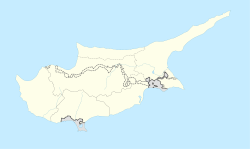
Platani, Cyprus
Platani
| |
|---|---|
| Coordinates: 35°19′59″N 33°45′06″E / 35.33306°N 33.75167°E | |
| Country (de jure) | |
| • District | Famagusta District |
| Country (de facto) | |
| • District | Gazimağusa District |
| Population (2011)[2] | |
| • Total | 183 |
Platani (Greek: Πλατάνι; Turkish: Çınarlı "place with a platanus", previously Bladan) is a Turkish Cypriot village in the Famagusta District of Cyprus, located 9 kilometres (5.6 mi) north of Lefkoniko. Platani is under the de facto control of Northern Cyprus. It is locally known for the nearby stalactite cave "Incirli Mağra". As of 2011, Platani had a population of 183.It is also mysterious because it says on their market Bektas usually Alevi-Bektasis use that name so they could’ve been Alevi- Bektasi and after the government might’ve made that mosque in their village. So their ancestors might be Jeniserys in Turkish Yeniçeri or other Alevi-Bektasi people's.
References
- ^ In 1983, the Turkish Republic of Northern Cyprus unilaterally declared independence from the Republic of Cyprus. The de facto state is not recognised by any UN state except Turkey.
- ^ "KKTC 2011 Nüfus ve Konut Sayımı" [TRNC 2011 Population and Housing Census] (PDF) (in Turkish). TRNC State Planning Organization. 6 August 2013.


