
Družec
Družec | |
|---|---|
Village | |
 Družec from the Calvary Rock | |
 Flag  Coat of arms | |
 Družec Location in the Czech Republic | |
| Coordinates: 50°06′09″N 14°02′42″E / 50.10250°N 14.04500°E | |
| Country | Czech Republic |
| Region | Central Bohemian |
| District | Kladno |
| Municipality | Kladno |
| First mention | 1320 |
| Government | |
| • Mayor | Marie Palková |
| Area | |
| • Total | 7.11 km2 (2.75 sq mi) |
| Elevation | 375 m (1,230 ft) |
| Population (2006) | |
| • Total | 939 |
| • Density | 130/km2 (340/sq mi) |
| Time zone | UTC+1 (CET) |
| • Summer (DST) | UTC+2 (CEST) |
| Postal code | 273 62 |
| Website | www.mesta.obce.cz/druzec/[permanent dead link] |
Družec is a village in Central Bohemian Region of the Czech Republic. It is located on the Loděnice stream about 27 km west of Prague and 6 km southwest of Kladno. R6 expressway from Prague to Karlovy Vary runs just north of the village. Pilgrimage church of the Assumption of Virgin Mary, partially surrounded with an old churchyard, dates back to first half of 14th century, but it was later (mainly in 1690s) rebuilt in Baroque style. Next to the church there is a sandstone Marian column from 1674 and a man-sized stone called Zkamenělec ("Man-turned-into-stone"), surrounded with legends of a punished perjurer or blasphemer.
-
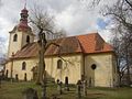 Church of the Assumption
 -
 Marian column from 1674 next to the church
 -
 Zkamenělec (Man-turned-into-stone)
 -
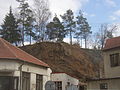 Calvary of Družec
 -
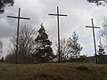 Calvary of Družec


External links
Wikimedia Commons has media related to Družec.
- Municipal website[permanent dead link] (in Czech)
| Authority control databases: National |
|---|