Kutrovice
Appearance
Kutrovice | |
|---|---|
Village | |
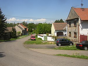
 Kutrovice as seen from south | |
| Etymology: Kutra's people | |
| Coordinates: 50°15′41″N 14°01′09″E / 50.26139°N 14.01917°E | |
| Country | Czech Republic |
| Region | Central Bohemian |
| District | Kladno |
| First mention | 1366 |
| Government | |
| • Mayor | Renata Jandová |
| Area | |
| • Total | 1.48 km2 (0.57 sq mi) |
| Elevation | 260 m (850 ft) |
| Population (2006) | |
| • Total | 108 |
| • Density | 73/km2 (190/sq mi) |
| Time zone | UTC+1 (CET) |
| • Summer (DST) | UTC+2 (CEST) |
| Postal code | 273 75 |
| Website | www.kutrovice.cz |
Kutrovice (Czech pronunciation: [ˈkutrovɪtsɛ]) is a village and municipality in the Central Bohemian Region of the Czech Republic located just north of the main road No. 7 from Prague to Chomutov (future R7 expressway), about 6 km northwest of Slaný or 35 km northwest of Prague. It has a population of 108 (2006).
Kutrovice lacks any buildings of higher historical importance, there is only a small Baroque chapel in the village.
|
External links
Wikimedia Commons has media related to Kutrovice.
- Municipal website (in Czech)


