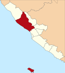
North Bengkulu Regency
North Bengkulu Regency
(Kabupaten Bengkulu Utara) | |
|---|---|
 | |
| Country | |
| Province | Bengkulu |
| Regency seat | Arga Makmur |
| Area | |
| • Total | 4,324.59 km2 (1,669.73 sq mi) |
| Population (2014) | |
| • Total | 274,614 |
| • Density | 64/km2 (160/sq mi) |
| Time zone | UTC+7 (WIB) |
North Bengkulu is a regency (Indonesian: kabupaten) of Bengkulu Province, Indonesia, on the island of Sumatra. Following the splitting off of the southerly ten districts to form a separate North Bengkulu Regency, it now covers an area of 4,324.59 km2, and at the 2010 Census it had a population of 257,675; the latest official estimate (as at January 2014) was 274,614.[1]
Administrative districts
The Regency is divided into twelve districts (Indonesian: kecamatan), detailed below with their areas and populations at the 2010 Census:[2]
| District | Area ( in km²) | Population 2010 Census[3] |
|---|---|---|
| Enggano | 196.9 | 2,691 |
| Kerkap | 288.5 | 22,874 |
| Air Napal | 108.7 | 11,523 |
| Air Besi | 92.3 | 10,323 |
| Arga Makmur | 233.3 | 47,457 |
| Lais | 228.8 | 17,195 |
| Batik Nau | 228.2 | 11,727 |
| Giri Mulya | 148.6 | 13,135 |
| Padang Jaya | 293.8 | 27,397 |
| Ketahun | 504.1 | 39,704 |
| Napal Putih | 916.7 | 17,582 |
| Putri Hijau | 336.8 | 36,067 |


