
Pleasant View, Colorado
Pleasant View, Colorado | |
|---|---|
 Looking north along Highway 491 in Pleasant View | |
 Location in Montezuma County and the state of Colorado  Pleasant View, Colorado (the United States) | |
| Coordinates: 37°35′18″N 108°45′57″W / 37.58833°N 108.76583°W | |
| Country | |
| State | |
| County | Montezuma[1] |
| Elevation | 6,913 ft (2,107 m) |
| Time zone | UTC-7 (MST) |
| • Summer (DST) | UTC-6 (MDT) |
| ZIP code[2] | 81331 |
| Area code | 970 |
| GNIS feature ID | 0176857 |
Pleasant View is an unincorporated community and a U.S. Post Office located in Montezuma County, Colorado, United States. The Pleasant View Post Office has the ZIP Code 81331.[2]
Pleasant View should not be confused with the census-designated places in Jefferson County known as West Pleasant View and East Pleasant View.
History
Several historic places near or in Pleasant View are on the Colorado State Register of Historic Properties or the National Register of Historic Places:[3][4]
- James A. Lancaster Site, also known as the Clawson Ruin, is an ancient pueblo archaeological site on the National Register of Historic Places
- Pigge Site, located near Lowry Ruin, contains several pueblo ruins and a great kiva and is also on the National Register.
- Puzzle House, is a pueblo settlement occupied three times, first about AD 650 and two occupations between AD 1075-1225. The site is on the state register.
Geography
Pleasant View is located at 37°35′18″N 108°45′57″W / 37.58833°N 108.76583°W (37.588391,-108.765850).
Demographics
The median income for a household was $16,631 in 2009. In 2000, the median income for a household was $45,897.
The median resident age was 38.6 years.[5]
Education
Pleasant View Public Schools are part of the Montezuma-Cortez School District RE-1. The district has one preschool, five elementary schools, one middle school and one high school.
Pleasant View Elementary School is located in Pleasant View. The other schools in the district are located in Cortez, and include Montezuma-Cortez RE-1 Pre-School, Kemper Elementary School, Lewis-Arriola Elementary School, Manaugh Elementary School, Mesa Elementary Schools, Cortez Middle School and Montezuma-Cortez High School. The high school mascot is the Panthers.
See also
- Canyons of the Ancients National Monument
- Colorado municipalities
- Hovenweep National Monument
- Lowry Ruin National Historic Landmark
- Old Spanish National Historic Trail
References
- ^ a b "US Board on Geographic Names". United States Geological Survey. 2007-10-25. Retrieved 2008-01-31.
- ^ a b "ZIP Code Lookup" (JavaScript/HTML). United States Postal Service. January 2, 2007. Retrieved January 2, 2007.
- ^ National & State Registers for Montezuma County, Colorado. Archived 2012-04-24 at the Wayback Machine Colorado Historical Society, Office of Archaeology and Historic Preservation. Retrieved 10-8-2011.
- ^ <<</state.html National Register of Historic Places in <<< County American Dreams, Inc. Retrieved 2011-10-6.
- ^ "Pleasant View, Colorado". City-Data.com. Retrieved 2012-07-07.
Municipalities and communities of Montezuma County, Colorado, United States | ||
|---|---|---|
| City | 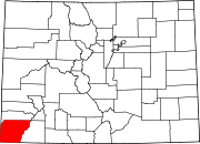 | |
| Towns | ||
| CDP | ||
| Unincorporated communities | ||
| Indian reservations | ||
| Footnotes | ‡This populated place also has portions in an adjacent county or counties | |