
Zaovine
Zaovine
Заовине | |
|---|---|
 Aerial view on Zaovine Lake | |
 Zaovine | |
| Coordinates: 43°51′N 19°21′E / 43.850°N 19.350°E | |
| Country | |
| District | Zlatibor District |
| Municipality | Bajina Bašta |
| Area | |
| • Total | 63.99 km2 (24.71 sq mi) |
| Elevation | 991 m (3,251 ft) |
| Population (2011) | |
| • Total | 263 |
| • Density | 4.1/km2 (11/sq mi) |
| Time zone | UTC+1 (CET) |
| • Summer (DST) | UTC+2 (CEST) |
| Postal code | 31251 |
| Area code | +381(0)31 |
| Car plates | BB |
Zaovine (Serbian Cyrillic: Заовине) is a village located in the municipality of Bajina Bašta, Serbia. According to the 2011 census, the village has a population of 263 inhabitants.[2] The whole territory of the village is a part of the Tara National park and is in close proximity of the Zaovine Lake.
Gallery
-
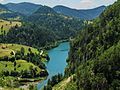
 Zaovine Lake
 -
 View on Zaovine Lake from the top of the nearby hill
 -
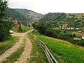 Zaovine village landscape
 -
 Zaovine village landscape
 -
 View on Zaovine lake from nearby hill
 -
 Zaovine Lake in early spring
.jpg)

.jpg)
.jpg)
.jpg)

References
- ^ "Насеља општине Бајина Башта" (PDF). stat.gov.rs (in Serbian). Statistical Office of Serbia. Retrieved 14 October 2019.
- ^ "COMPARATIVE OVERVIEW OF THE NUMBER OF POPULATION IN 1948, 1953, 1961, 1971, 1981, 1991, 2002 AND 2011" (PDF). stat.gov.rs. Statistical Office of Serbia. 30 September 2011. Retrieved 14 October 2019.
External links
Wikimedia Commons has media related to Zaovine.
This Zlatibor District, Serbia location article is a stub. You can help Wikipedia by expanding it. |