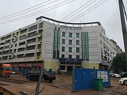
Changqing, Loudi
This article needs additional citations for verification. (September 2018) |
Changqing Subdistrict
长青街道 | |
|---|---|
 The Changqing Police Station. | |
| Coordinates: 27°43′44″N 111°59′25″E / 27.72889°N 111.99028°E | |
| Country | People's Republic of China |
| Province | Hunan |
| Prefecture-level city | Loudi |
| District | Louxing |
| Area | |
• Total | 5.5 km2 (2.1 sq mi) |
| Population (2015) | 70,000 |
| Time zone | UTC+8 (China Standard) |
| Postal code | 417000 |
| Area code | 0738 |
Changqing Subdistrict (simplified Chinese: 长青街道; traditional Chinese: 長青街道; pinyin: Chángqīng Jiēdào) is a subdistrict in Louxing Districtof Loudi City, Hunan Province, People's Republic of China.
Administrative division
[edit]The subdistrict is divided into 9 communities, the following areas:
- Zhushan Community (竹山社区)
- Guanjia Community (关家社区)
- Gengtang Community (耕塘社区)
- Louxing Community (娄星社区)
- Xiaohua Community (小花社区)
- Dongxin Community (洞新社区)
- Changqing Community (长青社区)
- Fuqing Community (扶青社区)
- Ganzichong Community (甘子冲社区)
Geography
[edit]Lianshui River, also known as the mother river, flows through the subdistrict.[1]
Economy
[edit]The local economy is primarily based upon commerce and local industry.
Hospital
[edit]The Loudi Central Hospital is situated at the subdistrict. The Chinese Medicine Hospital of Loudi is also sits in the subdistrict.[1]
Education
[edit]
Hunan University of Humanities, Science and Technology is a state-owned provincial university in the subdistrict.[1]
Transportation
[edit]Railway
[edit]The Luoyang–Zhanjiang Railway, from Luoyang City, Henan Province to Zhanjiang City, Guangdong Province runs through the subdistrict.[1]
The Shanghai–Kunming railway, more commonly known as "Hukun railway", is a west-east railway passing through the subdistrict.[1]
Attractions
[edit]Three public parks are located in the town: Shima Park, Zhushan Park (株山公园) and Xiannüzhai Ecological Park (仙女寨生态公园).[1]

