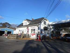
Wading River station
Wading River | ||||||||||||||||
|---|---|---|---|---|---|---|---|---|---|---|---|---|---|---|---|---|
 A local country store and beverage distributor built with wood originally used at the site of the nearby Wading River LIRR station. | ||||||||||||||||
| General information | ||||||||||||||||
| Location | Wading River–Manor Road Wading River, New York | |||||||||||||||
| Coordinates | 40°56′41″N 72°50′34″W / 40.944638°N 72.842663°W | |||||||||||||||
| Owned by | Long Island Rail Road (former) | |||||||||||||||
| Line(s) | ||||||||||||||||
| History | ||||||||||||||||
| Opened | 1895 | |||||||||||||||
| Closed | 1938 | |||||||||||||||
| Electrified | No | |||||||||||||||
| Services | ||||||||||||||||
None (closed)
| ||||||||||||||||
Wading River was the terminus of the abandoned Wading River Extension on the Port Jefferson Branch of the Long Island Rail Road. This is an abandoned station just outside south of downtown Wading River, and was located on Wading River-Manor Road (former Suffolk CR 25) north of New York State Route 25A.
History
Wading River station was originally built in 1895 during the extension of the Port Jefferson Branch to Wading River, and was once slated to continue eastward and rejoin the Main Line at either Riverhead or Calverton. Though neither of these proposals were carried out, it had a siding that crossed Wading River-Manor Road toward a coal bunker, and was extended to the site of an LIRR Demonstration farm from 1905 to 1928. The other demonstration farm was east of Medford station on the Main Line. The station was originally a one-story structure that was converted to a two-story structure in 1906. Besides the previously mentioned coal bunker extension, it also had a siding on the south side of the tracks, for an engine house, smaller coal bunker and water tank. The line east of Port Jefferson was abandoned in 1938, and the lumber from the station was used to build a nearby store north of the former station.[1] The right-of-way is now owned by the Long Island Power Authority and used for power lines, but there are plans to create a rail trail for bicycling, running, and walking.[2]
References
- ^ Bob Emery Map of Wading River Station & Vicinity
- ^ Rather, John (April 10, 2009). "Agreement Moves Rails-to-Trails Project Forward". New York Times. Retrieved October 15, 2009.
External links
- Wading River Extension (Unofficial LIRR History.com)
- Wading River Branch (Arrt's Arrchives)
- Former Wading River Long Island Rail Road Station (Road and Rail Pictures)
- Wading River Extension (TrainsAreFun)
