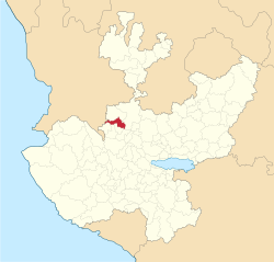
Magdalena, Jalisco
Magdalena | |
|---|---|
Municipality and city | |
 Location of the municipality in Jalisco | |
| Coordinates: 20°55′N 103°57′W / 20.917°N 103.950°W | |
| Country | |
| State | Jalisco |
| Area | |
| • Total | 445.36 km2 (171.95 sq mi) |
| Population (2005) | |
| • Total | 18,924 |
| Time zone | UTC-6 (Central Standard Time) |
| • Summer (DST) | UTC-5 (Central Daylight Time) |
Magdalena is a town and municipality in the state of Jalisco in central-western Mexico. Magdalena lies 78 kilometers northwest of Guadalajara. The municipality covers an area of 445.36 km². It borders the state of Nayarit to the west, and the town of Tequila to the east. As of 2005, the municipality had a total population of 18,924.[1]
Gems
Magdalena is famous for Fire opals; the whole regions accommodates hundreds of mines where Obsidian, Fire opals, and other rocks are produced.[2] In the town, there are several stores selling stones.
References
- ^ Enciclopedia de los Municipios de México, Instituto Nacional para el Federalismo y el Desarrollo Municipal, April 16, 2009.
- ^ "World Class Fire Opals Mined Near Puerto Vallarta". BanderasNews.
External links
- Chess Club Magdalena Jalisco
- Xochiltepec-Monte cubiero de flores - (Xochiltepec - The old name of Magdalena Jalisco)


