
Getargel
40°14′0″N 44°33′30″E / 40.23333°N 44.55833°E
Getragel
Գետարգել | |
|---|---|
_Monastery,_Arinj2.JPG) Dzagavank Monastery in Getargel | |
 Getragel | |
| Coordinates: 40°14′0″N 44°33′30″E / 40.23333°N 44.55833°E | |
| Country | Armenia |
| Marz (Province) | Kotayk |
| Population (2011 census) | |
| • Total | 795 |
| Time zone | UTC+4 ( ) |
Getargel (Armenian: Գետարգել), formerly known as Radiokayanin kits, or SMO is a village in the Kotayk Province of Armenia.
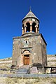
Dzagavank Monastery – also known as the Surp Nshan Monastery of Getargel – is located at the southern edge of the village. The monastery consists of two churches: the main church of Surp Nshan dating back to the 7th century, and the 13th-century two-story chapel. The monastic complex was entirely renovated between 2001 and 2004.
As of the 2011 census, the population of the village is 795.[1] Beside Armenians, the village has a Kurdish population.[2]
Gallery
-
 Church of Surp Nshan of Dzagavank Monastery of the 7th century
 -
 The 13th century chapel at Dzagavank Monastery
_S._Nshan_General_View.JPG)
_S._Nshan_Bell_Tower_1.JPG)
See also
References
- ^ Kotayk population
- ^ "Գետարգել համայնք" (in Armenian). Retrieved 20 May 2020.

This article about a location in Kotayk Province, Armenia is a stub. You can help Wikipedia by expanding it. |