Fransum
Appearance
You can help expand this article with text translated from the corresponding article in Dutch. (February 2014) Click [show] for important translation instructions.
|
Fransum | |
|---|---|
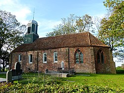
 The church of Fransum | |
| Coordinates: 53°16′41″N 6°26′50″E / 53.27806°N 6.44722°E | |
| Country | Netherlands |
| Province | Groningen |
| Municipality | Westerkwartier |
Fransum (Gronings: Fraansum) is an old church village in the municipality of Westerkwartier, Netherlands. The village in the northeast of the country contains an early 13th century Romanesque church, a farm and a house.
From Den Ham a narrow road leads to the wierde, with the last part being unpaved. A dodenweg, or 'death road' runs across the wierde from north to south. From Fransum there used to be church paths to Aduard, Altenaauw, Beswerd and Den Ham. Many of these paths disappeared later, but some have been restored as bike paths.
References
- Corresponding Dutch Wikipedia
- Meinema, J. (1997), Fransum: uit de geschiedenis van Fransum en zijn kerk. Onnen: 't Widde Vool. 31 p.
- IJzerman, M.J. et al. (1996), Den Ham en Fransum door de jaren heen. Bedum: Profiel. 94 p.
External links
 Media related to Fransum at Wikimedia Commons
