Richtweg station
Appearance
| Hamburg U-Bahn station | |||||||||||
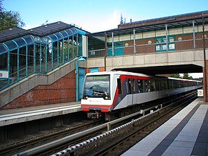
 Richtweg station with incoming train | |||||||||||
| General information | |||||||||||
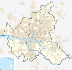
| Location | Norderstedt, Germany | ||||||||||
| Owned by | Verkehrsgesellschaft Norderstedt (VGN) | ||||||||||
| Line(s) | Template:ÖPNV Hamburg | ||||||||||
| Platforms | 2 side platforms | ||||||||||
| Tracks | 2 | ||||||||||
| Construction | |||||||||||
| Structure type | At-grade | ||||||||||
| Accessible | Yes | ||||||||||
| Other information | |||||||||||
| Station code | ID:[1] 895139 | ||||||||||
| Fare zone | HVV: B/403[2] | ||||||||||
| History | |||||||||||
| Opened | 17 May 1953 | ||||||||||
| Rebuilt | 28 September 1996 | ||||||||||
| Electrified | 750 volts DC system third rail | ||||||||||
| Services | |||||||||||
| |||||||||||
| |||||||||||
Richtweg is a public transport station for the rapid transit trains of Hamburg's underground railway line U1, located in Norderstedt, Germany.
It was opened 1953 as a stop of the Alster Northern Railway (ANB) from Ulzburg Süd to Ochsenzoll with an island platform. Between 1994 and 1996 this section of the ANB was rebuilt for the Hamburg U-Bahn system.
Station layout
The station is a side platform station with a passenger bridge crossing at the north and exits to both sides of it.
See also
- Hamburger Verkehrsverbund Public transport association in Hamburg
- Hamburger Hochbahn Operator of the Hamburg U-Bahn
References
- ^ International station id (German:IBNR)
- ^ "Tarifplan" (PDF). Hamburger Verkehrsverbund. 9 December 2018. Retrieved 14 October 2019.
External links
![]() Media related to U-Bahnhof Richtweg at Wikimedia Commons
Media related to U-Bahnhof Richtweg at Wikimedia Commons
- Network plan HVV (pdf) 560 KiB
53°41′44″N 9°59′22″E / 53.69556°N 9.98944°E


