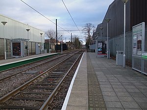
Beddington Lane tram stop
Appearance
 | |
| General information | |
| Location | Beddington Lane Sutton United Kingdom |
| Coordinates | 51°23′22″N 0°08′34″W / 51.3895°N 0.1429°W |
| Operated by | Tramlink |
| Platforms | 2 |
| Construction | |
| Accessible | Yes |
| Other information | |
| Fare zone | London fare zones 3, 4, 5 and 6 |
| History | |
| Opened | 2000 |
| Passengers | |
| 2009–10 | 0.214 million total boardings and alightings[1] |
| 2010–11 | 0.221 million total boardings and alightings[2] |


Beddington Lane tram stop is a stop on the Croydon Tramlink tramway. There was previously a railway station on this site, on the single track line from Wimbledon to Croydon, which closed in 1997 in order for it to be converted for Tramlink use. The stop is accessible from the east from Beddington Lane, and also from the pathway leading to the west and south. In late 2014, the track immediately to the west of the tram stop was doubled, though further west the bridge carrying trams over the main line at Mitcham Junction station is still single-track.
Connections
London Buses route 463 serves the tram stop while routes 264 and 455 are a short walk from the stop.
| Preceding station | Following station | |||
|---|---|---|---|---|
toward Template:Tramlink stations | Template:Tramlink lines | toward Template:Tramlink stations |
||
| Template:Tramlink lines | toward Template:Tramlink stations |
References
Wikimedia Commons has media related to Beddington Lane tram stop.
- ^ "Tram Stop Usage 2009-10 (FOI)" (XLS). Tramlink annual passenger performance 2009-2010. Transport for London. 18 August 2011. Retrieved 28 November 2012.
- ^ "Tramlink numbers 2010-2011" (PDF). Tramlink annual passenger performance 2010-2011. Transport for London. 28 March 2012. Retrieved 28 November 2012.
