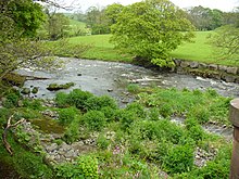
Scalthwaiterigg
Appearance

Scalthwaiterigg is a former civil parish, now in the parish of Skelsmergh and Scalthwaiterigg, in South Lakeland, Cumbria, England, immediately north east of Kendal. It previously had a joint parish council with the adjacent parish of Skelsmergh.[1][2][3][4]
There were three listed buildings or structures in the parish: the 16th-century farmhouse Benson Hall and two bridges.[5][6]
References
- ^ "Skelsmergh and Scalthwaiterigg Parish Council". Cumbria County Council. Retrieved 6 March 2016.
- ^ "Skelsmergh and Scalthwaiterigg Parish Council". South Lakeland District Council. Retrieved 6 March 2016.
- ^ "Skelsmergh & Scalthwaiterigg Parish Council". Retrieved 6 March 2016.
- ^ "South Lakeland District (Parishes of Skelsmergh and Scalthwaiterigg) Grouping Order 2007" (PDF). Local Government Boundary Commission for England. Retrieved 1 February 2020.
- ^ "Advanced search". National Heritage List for England. Historic England. Enter parish name to search
- ^ Historic England. "Benson Hall (1311740)". National Heritage List for England. Retrieved 6 March 2016.
Further reading
- Farrer, William; Curwen, John F (1924). "Scalthwaiterigg, Hay, Hutton in the Hay and New Hutton". Records Relating To the Barony of Kendale: Volume 1. pp. 176–186.
External links
- "Scalthwaiterigg through time". Vision of Britain.
54°20′57″N 2°42′03″W / 54.3492°N 2.7008°W
