
Pasikot
Pasikot
पासिकोट | |
|---|---|
 Pasikot Location in Nepal | |
| Coordinates: 27°46′N 85°22′E / 27.767°N 85.367°E | |
| Country | |
| Province | Bagmati Pradesh |
| District | Kathmandu District |
| Population (2011) | |
| • Total | 107,918 |
| • Ethnicities | Newar Bahun Chhetri Tamang Magar |
| • Religions | Hindu Buddhist |
| Time zone | UTC+5:45 (NST) |
| Website | [1] |
Pasikot, situated at Budhanilkantha Municipality, is a village in Budhanilkantha in Kathmandu District in Bagmati Pradesh before being incorporated into the city of Budhanilkantha (along with Chapali Bhadrakali, Mahankal, Bishnu, Chunikhel and Kapan) in Nepal. At the time of the 2011 Nepal census it had a population of 15,421.[1]
Population
The total population of the village is 107918 according to census of 2011. The population varies with in people of different ethnic groups. This village has the largest area among others
Scenery
See the Clear Scene of Pasikot on YouTube: Pasikot - पासिकोट - Budhanilkantha Municipality | Scene of Pasikot Village - Clear Environment
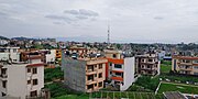
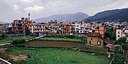
Pasikot is a beautiful village with nice view. Many people live in this village and it has a lot of good facilities. This village is like town where you can get all the facilities. It often rains and the view becomes amazing as it gets clear.
-
 Clear view of Pasikot in the East
 -
 Clear view of Pasikot in the South-East
 -
 Clear view of Pasikot in the South
 -
 Clear view of Pasikot in the North-West
 -
 Clear view of Pasikot in the North-East


