Aizkraukle Municipality
Aizkraukle Municipality
Aizkraukles novads | |
|---|---|
 | |
| Country | |
| Formed | 2001 |
| Centre | Aizkraukle |
| Government | |
| • Chairman | Leons Līdums (VP) |
| Area | |
| • Total | 102.3 km2 (39.5 sq mi) |
| Population (2009)[2] | |
| • Total | 10,080 |
| • Density | 99/km2 (260/sq mi) |
| Website | www |
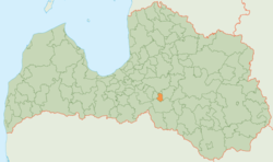
Aizkraukle Municipality (Latvian: Aizkraukles novads) is a municipality in Vidzeme, Latvia. The municipality was formed in 2001 by merging town Aizkraukle and Aizkraukle Parish the administrative centre being Aizkraukle.
Twin towns – sister cities
Aizkraukle is twinned with:[3]
See also
References
- ^ The Ministry of Regional Development and Local Government of the Republic of Latvia Archived 2014-02-07 at the Wayback Machine
- ^ "The Central Election Commission of Latvia". Archived from the original on 2012-04-06. Retrieved 2009-07-24.
- ^ "Starptautiskā sadarbība". aizkraukle.lv (in Latvian). Aizkraukles novads. Retrieved 2020-03-30.
56°36′15″N 25°15′14″E / 56.60417°N 25.25389°E

