
Dej
This article needs additional citations for verification. (June 2016) |
Dej | |
|---|---|
 Dej Calvinist Church | |
 Coat of arms | |
 Location in Cluj County | |
 Dej Location in Romania | |
| Coordinates: 47°05′14″N 23°48′19″E / 47.08722°N 23.80528°E | |
| Country | Romania |
| County | Cluj |
| Government | |
| • Mayor | Costan Morar[1] (PSD) |
| Area | 109.12 km2 (42.13 sq mi) |
| Population (2021-12-01)[2] | 31,475 |
| • Density | 290/km2 (750/sq mi) |
| Time zone | EET/EEST (UTC+2/+3) |
| Vehicle reg. | CJ |
| Website | www |
Dej (Romanian pronunciation: [deʒ]; Hungarian: Dés; German: Desch, Burglos; Yiddish: דעעש Desh) is a municipality in Transylvania, Romania, 60 km (40 miles) north of Cluj-Napoca, in Cluj County. It lies where the river Someșul Mic meets the river Someșul Mare. The city administers four villages: Ocna Dejului (Désakna), Peștera (Pestes), Pintic (Oláhpéntek) and Șomcutu Mic (Kissomkút).[citation needed]
The city lies at the crossroads of important railroads and highways linking it to Cluj-Napoca, Baia Mare, Satu Mare, Deda, Bistrița, and Vatra Dornei.
History

Like the rest of the territory of Cluj County, Dej was part of Hungary prior to 1920. The city was first mentioned in 1214 as Dees, in 1236 as Deeswar, in 1310 as Deesvitta, in 1351 both Deés[3] and Deésvár occurred, the earlier has been used until eventually it was changed to Dés. It had a royal charter as a free city and was the capital of Szolnok-Doboka County.[3] In 1905 it had a protestant church from the 15th Century, and a tower from 16th Century fortifications.[3] It was primarily a market town for local wines and other agricultural products.[4]
Demographics
| Year | Pop. | ±% |
|---|---|---|
| 1910 | 11,452 | — |
| 1930 | 15,110 | +31.9% |
| 1948 | 14,681 | −2.8% |
| 1956 | 19,281 | +31.3% |
| 1966 | 26,984 | +40.0% |
| 1977 | 32,345 | +19.9% |
| 1992 | 41,216 | +27.4% |
| 2002 | 38,478 | −6.6% |
| 2011 | 33,497 | −12.9% |
| Source: Census data | ||
According to the 2011 Romanian census, there were 33,497 people living within the city.
Of this population, 81.8% are ethnic Romanians, while 11.3% are ethnic Hungarians, 1.0% Roma and 0.1% others.[5]
Natives
- Nicolae Blatt
- Zsigmond Czakó
- Ana Novac
- Adriana Săftoiu
- Lavinia Șandru
- Itamar Singer
- Raoul Șorban
- Károly Ferenc Szabó
- Géza Teleki
Gallery
-
 Dej in 1902
 -
 The City Hall
 -
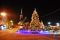 City Square at Night
 -
 Avram Iancu Street
 -
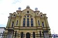 Synagogue in Dej
 -
 Pentecostal Temple in Dej
 -
 The Roman Catholic Church
 -
 Greek-Catholic Church in 1 Mai
 -
 Andrei Muresanu National College
 -
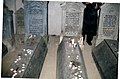 Graves in the Jewish cemetery of Dej


References
- ^ "Results of the 2016 local elections". Central Electoral Bureau. Retrieved 3 April 2020.
- ^ "Populaţia rezidentă după grupa de vârstă, pe județe și municipii, orașe, comune, la 1 decembrie 2021" (XLS). National Institute of Statistics.
- ^ a b c "Deés". Austria-Hungary: Including Dalmatia and Bosnia; Handbook for Travellers. Karl Baedeker. 1905. p. 406.
- ^ Ritter, Carl (1874). "Deés". Geographisch-statistisches Lexikon über die Erdteile, Länder, Meere, Buchten, Häfen, Seen, Flüsse, Inseln, Gebirge, Staaten, Städte, Flecken, Dörfer, Weiler, Bäder, Bergwerke, Kanäle etc (in German). Wigand. p. 375.
- ^ Tab8. Populaţia stabilă după etnie – judeţe, municipii, oraşe, comune, 2011 census results, Institutul Național de Statistică, accessed 17 February 2020.
External links

| International | |
|---|---|
| National | |