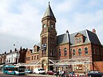
Garston Dock railway station
Garston Dock Railway Station | |
|---|---|
| General information | |
| Location | Liverpool |
| Coordinates | 53°20′55″N 2°47′01″W / 53.3485°N 2.78366°W |
| Platforms | 2 |
| History | |
| Original company | St Helens Railway |
| Pre-grouping | LNWR |
| Post-grouping | London Midland and Scottish Railway |
| Key dates | |
| 1852 | Opened |
| 5 April 1917<[1] | closed |
| 5 May 1919 | reopened |
| 16 June 1947 | Closed |
Garston Dock railway station served Garston, Liverpool, Merseyside, England. It was situated on the east side of Dock Road.
History
The station opened on 1 July 1852 as the western terminal of the St Helens and Runcorn Gap Railway and closed 16 June 1947.[2] Soon after the station was opened the Garston and Liverpool Railway was opened bringing the St Helens Railway Liverpool terminus to Brunswick. However the Cheshire Lines Committee took over this line to connect in Liverpool to Manchester Line to central Liverpool. So the LNWR which by this time had acquired the St Helens Railway built Hunts Cross chord allowing its trains to access its Liverpool Lime Street railway station.
| Preceding station | Disused railways | Following station | ||
|---|---|---|---|---|
| Terminus | LNWR St Helens Railway |
Church Road Garston | ||
| Cressington | CLC Garston and Liverpool Railway |
Terminus |

References
See also
Categories:
- Disused railway stations in Liverpool
- Railway stations in Great Britain opened in 1852
- Railway stations in Great Britain closed in 1917
- Railway stations in Great Britain opened in 1919
- Railway stations in Great Britain closed in 1947
- Former London and North Western Railway stations
- 1852 establishments in England
- Merseyside railway station stubs


