
Ladenburg
You can help expand this article with text translated from the corresponding article in German. (February 2009) Click [show] for important translation instructions.
|
Ladenburg | |
|---|---|
.JPG) Marktplatz | |
|
Flag  Coat of arms | |
Location of Ladenburg within Rhein-Neckar-Kreis district 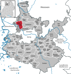 | |
 Ladenburg  Ladenburg | |
| Coordinates: 49°28′N 8°37′E / 49.467°N 8.617°E | |
| Country | Germany |
| State | Baden-Württemberg |
| Admin. region | Karlsruhe |
| District | Rhein-Neckar-Kreis |
| Subdivisions | Town with hamlet |
| Government | |
| • Mayor | Stefan Schmutz (SPD) |
| Area | |
| • Total | 19 km2 (7 sq mi) |
| Elevation | 106 m (348 ft) |
| Population (2022-12-31)[1] | |
| • Total | 12,517 |
| • Density | 660/km2 (1,700/sq mi) |
| Time zone | UTC+01:00 (CET) |
| • Summer (DST) | UTC+02:00 (CEST) |
| Postal codes | 68520–68526 |
| Dialling codes | 06203 |
| Vehicle registration | HD |
| Website | www.ladenburg.de |

Ladenburg is a town in the district of Rhein-Neckar-Kreis, in Baden-Württemberg, Germany. It is situated on the right bank of the Neckar, 10 kilometres (6 miles) east of Mannheim, and 10 km (6 mi) northwest of Heidelberg.
Ladenburg's history dates back to Celtic and Roman ages. In Roman times it was called 'Lopodunum'. Emperor Trajan elevated it to the status of a city ('civitas') in the year 98. Its old centre dates back to the Late Middle Age.
Ladenburg is located on Bertha Benz Memorial Route.

Mayors
List of mayors:[2]
|
|
Notable residents
- Johann Friedrich von Seilern (1646–1715), son of a dyer and later Imperial Count, was born in Ladenburg.
- Johann Christoph Sauer (1695–1757), the first German-language printer and publisher in North America, was born in Ladenburg
- Franz Xaver(1780-1844) and Friedrich von Hertling, Bavarian war ministers, were born in Ladenburg.
- Michael Frey (1787-1832), composer, violinist and conductor
- Lambert Heinrich von Babo (1818-1899), chemist
- Karl Benz, (1844-1929), inventor of the automobile, lived in Ladenburg between 1906 and his death in 1929.
- Martin Hartmann (1870-1931), lawyer, head of the Baden office
- Rudolf Agricola (1900-1985), economist and journalist
History
.jpg)
The first time this village was populated was between 3000 and 200 BC. It then consisted of a Celtic settlement Lopodunum (="sea tower"). In the year 40 the Romans populated the town as a farmer/military outpost and kept its Celtic name. The local territory formed the civilian district of Civitas Ulpia Sueborum Nicretum ("Neckarsuebi"), of which Lopodunum was the chief town. In 74 AD the Romans founded the town Auxiliarkastelle which included a supply-keeping town, which was the center of the future town. The garrison included a regiment of cavalry made up from the Canaefaten.
International relations
Twin towns – Sister cities
Ladenburg is twinned with:
References
- ^ "Bevölkerung nach Nationalität und Geschlecht am 31. Dezember 2022" [Population by nationality and sex as of December 31, 2022] (CSV) (in German). Statistisches Landesamt Baden-Württemberg. June 2023.
- ^ Ladenburg-Lexikon. Norderstedt 2007, ISBN 978-3-8334-6799-8.
- ^ "Jumelage Laval-Garango" (in French). Retrieved 2013-06-13.
External links

| International | |
|---|---|
| National | |
| Geographic | |
| Other | |
This Rhein-Neckar-Kreis location article is a stub. You can help Wikipedia by expanding it. |