Sila Region
Sila
Dar Sila | |
|---|---|
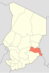
 Map of Chad showing Sila. | |
| Coordinates: 12°13′25″N 21°24′52″E / 12.22361°N 21.41444°E | |
| Country | Chad |
| Departments | 2 |
| Sub-prefectures | 10 |
| Region | 2008 |
| Regional capital | Goz Beïda |
| Population (2009)[1] | |
• Total | 387,461 |
Sila or Dar Sila[2] is a region of Chad, located in the south-east of the country. It was created in 2008 from the departments of Sila and Djourf Al Ahmar which were previously part of Ouaddaï Region.[3] The capital of the region is Goz Beïda.
Geography
The region borders Ouaddaï Region to the north, Sudan to the east, the Central African Republic to the south-east, Salamat Region to the south-west, and Guéra Region to the west. The terrain is generally flat savannah, with some scattered hills.
Settlements
Goz Beïda is the capital of the region; other major settlements include Adé, Am Dam, Haouich, Kerfi, Koukou Angarana, Magrane, Mogororo, Moudeïna and Tissi.[4]
Demographics
As per the 2009 Chadian census, Sila has a population of 387,461.[1] The main ethnolinguistic groups are the Birgit, Dar Sila Daju, Fongoro, Fur, Kajakse, Karanga, Kibet, Kujarge, Runga and Sinyar.[5]
Subdivisions
Sila is divided into two departments:
| Department | Capital (chef-lieu) | Sub-prefectures |
|---|---|---|
| Djourf Al Ahmar | Am Dam | Am Dam, Magrane, Haouich |
| Kimiti | Goz Beïda | Goz Beïda, Koukou-Angarana, Tissi, Adé, Mogororo, Kerfi, Moudeïna |
See also
References
- ^ a b DEUXIEME RECENSEMENT GENERAL DE LA POPULATION ET DE L’HABITAT: RESULTATS GLOBAUX DEFINITIFS (PDF) (Report). INSEED. March 2012. p. 24. Retrieved 10 March 2017.
- ^ "Map of Chad, showing region names and borders" (PDF). United Nations Cartographic Section. Retrieved 30 August 2012.
- ^ "Ordonnance n° 002/PR/08 portant restructuration de certaines collectivités territoriales décentralisées" [Ordinance No. 002/PR/08 on restructuring of certain decentralized local authorities]. Government of Chad. 19 February 2008. Archived from the original on March 4, 2016.
- ^ "Tchad : Région du Sila - Juin 2010" (PDF). UNOCHA. Retrieved 27 September 2019.
- ^ "Languages of Chad". Ethnologue. Retrieved 27 September 2019.
