
Dipaculao
Dipaculao | |
|---|---|
| Municipality of Dipaculao | |
 | |
 Map of Aurora with Dipaculao highlighted | |
OpenStreetMap  | |
.svg) Dipaculao Location within the Philippines | |
| Coordinates: 15°59′N 121°38′E / 15.98°N 121.63°E | |
| Country | |
| Region | Central Luzon |
| Province | Aurora |
| District | Lone District |
| Founded | 1950 |
| Barangays | 25 (see Barangays) |
| Government | |
| • Type | Sangguniang Bayan |
| • Mayor | Isacar Velasco |
| • Vice Mayor | Niel Vincent Sorongon |
| • Congressman | Lyka Raguindin |
| • Electorate | 21,125 voters (2022) |
| Area | |
| • Total | 361.64 km2 (139.63 sq mi) |
| Elevation | 45 m (148 ft) |
| Population (2020 census)[3] | |
| • Total | 33,131 |
| • Density | 92/km2 (240/sq mi) |
| • Households | 8,183 |
| Economy | |
| • Income class | 3rd municipal income class |
| • Poverty incidence | 12.27% (2015)[4] |
| • Revenue (₱) | ₱ 173.7 million (2020) |
| • Assets (₱) | ₱ 323 million (2020) |
| • Liabilities (₱) | ₱ 40.34 million (2020) |
| • Expenditure (₱) | ₱ 157.3 million (2020) |
| Time zone | UTC+8 (PST) |
| ZIP code | 3203 |
| PSGC | |
| IDD : area code | +63 (0)42 |
| Native languages | Ilocano Tagalog |
| Website | www |
Dipaculao, officially the Municipality of Dipaculao (Tagalog: Bayan ng Dipaculao; Ilocano: Ili ti Dipaculao), is a 3rd class municipality in the province of Aurora, Philippines. According to the 2020 census, it has a population of 33,131 people.[3]
The municipality is home to the Dinadiawan River Protected Landscape.
History
On June 21, 1957 the sitios of Dimabono, Laboy, Dinadiawan and Puangi were converted into barrios.[5][6][7][8] Several more sitios were converted into barrios on June 18, 1966.[9]
Geography
According to the Philippine Statistics Authority, the municipality has a land area of 361.64 square kilometres (139.63 sq mi) [2] constituting 11.49% of the 3,147.32-square-kilometre- (1,215.19 sq mi) total area of Aurora.
Barangays
Dipaculao is politically subdivided into 25 barangays.[10]
| PSGC | Barangay | Population | ±% p.a. | |||
|---|---|---|---|---|---|---|
| 2020[3] | 2010[11] | |||||
| 037706001 | Bayabas | 2.8% | 915 | 914 | 0.01% | |
| 037706003 | Borlongan | 7.3% | 2,416 | 2,173 | 1.07% | |
| 037706002 | Buenavista | 1.7% | 569 | 554 | 0.27% | |
| 037706004 | Calaocan | 2.5% | 816 | 873 | −0.67% | |
| 037706025 | Diamanen | 1.0% | 331 | 172 | 6.76% | |
| 037706005 | Dianed | 2.2% | 722 | 588 | 2.07% | |
| 037706006 | Diarabasin | 5.2% | 1,730 | 1,621 | 0.65% | |
| 037706007 | Dibutunan | 2.6% | 860 | 723 | 1.75% | |
| 037706008 | Dimabuno | 3.6% | 1,195 | 1,023 | 1.57% | |
| 037706009 | Dinadiawan | 11.3% | 3,733 | 3,670 | 0.17% | |
| 037706010 | Ditale | 4.2% | 1,398 | 1,297 | 0.75% | |
| 037706011 | Gupa | 3.1% | 1,037 | 991 | 0.45% | |
| 037706012 | Ipil | 3.5% | 1,154 | 1,149 | 0.04% | |
| 037706013 | Laboy | 1.4% | 454 | 404 | 1.17% | |
| 037706014 | Lipit | 2.9% | 968 | 818 | 1.70% | |
| 037706015 | Lobbot | 1.8% | 580 | 475 | 2.02% | |
| 037706016 | Maligaya | 2.0% | 665 | 574 | 1.48% | |
| 037706017 | Mijares | 3.4% | 1,134 | 1,014 | 1.12% | |
| 037706018 | Mucdol | 4.5% | 1,479 | 1,476 | 0.02% | |
| 037706019 | North Poblacion | 6.2% | 2,059 | 2,058 | 0.00% | |
| 037706020 | Puangi | 4.3% | 1,430 | 1,314 | 0.85% | |
| 037706021 | Salay | 4.3% | 1,417 | 1,323 | 0.69% | |
| 037706022 | Sapangkawayan | 1.2% | 405 | 349 | 1.50% | |
| 037706023 | South Poblacion | 5.1% | 1,693 | 1,688 | 0.03% | |
| 037706024 | Toytoyan | 1.7% | 576 | 488 | 1.67% | |
| Total | 33,131 | 27,729 | 1.80% | |||
Climate
| Climate data for Dipaculao, Aurora | |||||||||||||
|---|---|---|---|---|---|---|---|---|---|---|---|---|---|
| Month | Jan | Feb | Mar | Apr | May | Jun | Jul | Aug | Sep | Oct | Nov | Dec | Year |
| Mean daily maximum °C (°F) | 27 (81) |
28 (82) |
29 (84) |
31 (88) |
31 (88) |
31 (88) |
30 (86) |
30 (86) |
30 (86) |
30 (86) |
29 (84) |
27 (81) |
29 (85) |
| Mean daily minimum °C (°F) | 21 (70) |
21 (70) |
22 (72) |
24 (75) |
25 (77) |
25 (77) |
25 (77) |
25 (77) |
25 (77) |
24 (75) |
23 (73) |
22 (72) |
24 (74) |
| Average precipitation mm (inches) | 41 (1.6) |
39 (1.5) |
35 (1.4) |
54 (2.1) |
198 (7.8) |
246 (9.7) |
305 (12.0) |
300 (11.8) |
274 (10.8) |
192 (7.6) |
77 (3.0) |
69 (2.7) |
1,830 (72) |
| Average rainy days | 13.0 | 11.1 | 11.2 | 12.5 | 21.7 | 24.8 | 27.4 | 28.0 | 26.0 | 20.6 | 13.6 | 14.7 | 224.6 |
| Source: Meteoblue (modeled/calculated data, not measured locally)[12] | |||||||||||||
Demographics
|
| ||||||||||||||||||||||||||||||||||||
| Source: Philippine Statistics Authority[13][11][14][15] | |||||||||||||||||||||||||||||||||||||
In the 2020 census, Dipaculao had a population of 33,131.[3] The population density was 92 inhabitants per square kilometre (240/sq mi).
Gallery
-
 South Poblacion
 -
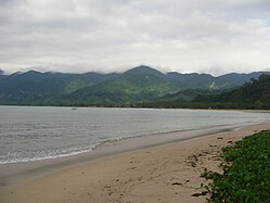 Dinadiawan white beach (a long stretch of clean, fine, golden white sand coastline)
 -
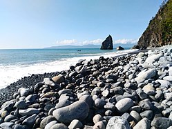
 Rock formations along the shoreline (north of Baler along the Dicadi highway)
 -
 Ampere Beach and Ampere Rock in Dipaculao


References
- ^ Municipality of Dipaculao | (DILG)
- ^ a b "Province: Aurora". PSGC Interactive. Quezon City, Philippines: Philippine Statistics Authority. Retrieved 12 November 2016.
- ^ a b c d Census of Population (2020). "Region III (Central Luzon)". Total Population by Province, City, Municipality and Barangay. Philippine Statistics Authority. Retrieved 8 July 2021.
- ^ "PSA releases the 2015 Municipal and City Level Poverty Estimates". Quezon City, Philippines. Retrieved 12 October 2019.
- ^ "Republic Act No. 1761; An Act Creating the Barrio of Laboy in the Municipality of Dipaculao, Province of Quezon". PhilippineLaw.info. 21 June 1957. Archived from the original on 15 May 2012. Retrieved 6 November 2016.
- ^ "Republic Act No. 1762; An Act Creating the Barrio of Dinadiawan in the Municipality of Dipaculao, Province of Quezon". PhilippineLaw.info. 21 June 1957. Archived from the original on 15 May 2012. Retrieved 6 November 2016.
- ^ "Republic Act No. 1763; An Act Creating the Barrio of Puangi in the Municipality of Dipaculao, Province of Quezon". PhilippineLaw.info. 21 June 1957. Archived from the original on 15 May 2012. Retrieved 6 November 2016.
- ^ "Republic Act No. 1764; An Act Creating the Barrio of Dimabono in the Municipality of Dipaculao, Province of Quezon". PhilippineLaw.info. 21 June 1957. Archived from the original on 15 May 2012. Retrieved 6 November 2016.
- ^ "Republic Act No. 4809; Republic Act No. 4809 - An Act Creating Certain Barrios in the Municipalities of Dipaculao and San Luis and the Municipal District of Dilasag, Province of Quezon". Chan Robles Virtual Law Library. 18 June 1966. Archived from the original on 25 September 2013. Retrieved 6 November 2016.
- ^ "Municipal: Dipaculao". PSGC Interactive. Quezon City, Philippines: Philippine Statistics Authority. Retrieved 8 January 2016.
- ^ a b Census of Population and Housing (2010). "Region III (Central Luzon)" (PDF). Total Population by Province, City, Municipality and Barangay. National Statistics Office. Retrieved 29 June 2016.
- ^ "Dipaculao, Aurora: Average Temperatures and Rainfall". Meteoblue. Retrieved 27 December 2018.
- ^ Census of Population (2015). "Region III (Central Luzon)". Total Population by Province, City, Municipality and Barangay. Philippine Statistics Authority. Retrieved 20 June 2016.
- ^ Censuses of Population (1903–2007). "Region III (Central Luzon)". Table 1. Population Enumerated in Various Censuses by Province/Highly Urbanized City: 1903 to 2007. National Statistics Office.
{{cite encyclopedia}}: CS1 maint: numeric names: authors list (link) - ^ "Province of Aurora". Municipality Population Data. Local Water Utilities Administration Research Division. Retrieved 17 December 2016.
External links
Places adjacent to Dipaculao | |
|---|---|
| Municipalities | |
|---|---|
| Barangays | |