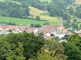
Menat, Puy-de-Dôme
Appearance
Menat | |
|---|---|
 Village de Menat | |
| Coordinates: 46°06′16″N 2°54′19″E / 46.1044°N 2.9053°E | |
| Country | France |
| Region | Auvergne-Rhône-Alpes |
| Department | Puy-de-Dôme |
| Arrondissement | Riom |
| Canton | Saint-Éloy-les-Mines |
| Intercommunality | CC Pays de Saint-Éloy |
| Government | |
| • Mayor (2008–2014) | Daniel Mazuel[1] |
| Area 1 | 20.31 km2 (7.84 sq mi) |
| Population (2021)[2] | 540 |
| • Density | 27/km2 (69/sq mi) |
| Demonym | Menatois |
| Time zone | UTC+01:00 (CET) |
| • Summer (DST) | UTC+02:00 (CEST) |
| INSEE/Postal code | 63223 /63560 |
| Elevation | 346–674 m (1,135–2,211 ft) |
| Website | www.commune-de-menat.com |
| 1 French Land Register data, which excludes lakes, ponds, glaciers > 1 km2 (0.386 sq mi or 247 acres) and river estuaries. | |
Menat is a commune in the Puy-de-Dôme department in Auvergne in central France.
Gastronomy
The pâté aux pommes de terre and, the "pain des Combrailles" are specialities of the region.[3]
See also
References
- ^ Site de la préfecture du Puy-de-Dôme, consulté le 8 janvier 2009
- ^ "Populations légales 2021" (in French). The National Institute of Statistics and Economic Studies. 28 December 2023.
- ^ "The Auvergne". Archived from the original on 2009-01-02. Retrieved 2009-01-13.
Wikimedia Commons has media related to Menat.


