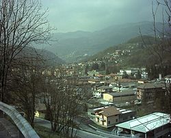
Sant'Omobono Terme
Sant’Omobono Terme | |
|---|---|
| Comune di Sant’Omobono Terme | |
 Sant'Omobono Terme | |
| Coordinates: 45°49′N 9°32′E / 45.817°N 9.533°E | |
| Country | Italy |
| Region | Lombardy |
| Province | Bergamo (BG) |
| Frazioni | Cepino, Mazzoleni, Selino Alto, Selino Basso (communal seat), Valsecca |
| Government | |
| • Mayor | Manzoni Sauro Ivo[1] |
| Area | |
| • Total | 10.8 km2 (4.2 sq mi) |
| Elevation | 427 m (1,401 ft) |
| Population (31 January 2014)[2] | |
| • Total | 3,978 |
| • Density | 370/km2 (950/sq mi) |
| Demonym | Santomobonesi |
| Time zone | UTC+1 (CET) |
| • Summer (DST) | UTC+2 (CEST) |
| Postal code | 24038 |
| Dialing code | 035 |
Sant'Omobono Terme (previously Sant'Omobono Imagna; Bergamasque: Sant' Imbù) is a comune (municipality) in the Province of Bergamo in the Italian region of Lombardy, located about 50 kilometres (31 mi) northeast of Milan and about 15 kilometres (9 mi) northwest of Bergamo.
Sant' Omobono Imagna borders the following municipalities: Bedulita, Berbenno, Brembilla, Corna Imagna, Costa Valle Imagna, Roncola, Rota d'Imagna. The former commune of Valsecca was merged with Sant'Omobono in 2014.
References
- ^ http://www.comune.santomobonoterme.bg.it/zf/index.php/organi-politico-amministrativo/index/detail/categoria/77/idOrgano/GTlRVPQ--H
- ^ All demographics and other statistics: Italian statistical institute Istat.


