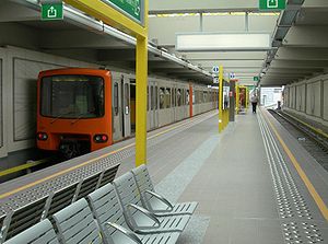
Delacroix metro station
Appearance
 Delacroix metro station | |||||||||||||||
| General information | |||||||||||||||
| Location | Rue Delacroix / Delacroixstraat B-1070 Anderlecht, Brussels-Capital Region, Belgium | ||||||||||||||
| Coordinates | 50°50′42″N 4°19′28″E / 50.84500°N 4.32444°E | ||||||||||||||
| Owned by | STIB/MIVB | ||||||||||||||
| Platforms | Island platform | ||||||||||||||
| Tracks | 2 | ||||||||||||||
| Construction | |||||||||||||||
| Structure type | Elevated | ||||||||||||||
| History | |||||||||||||||
| Opened | 4 September 2006 | ||||||||||||||
| Services | |||||||||||||||
| |||||||||||||||
Delacroix is a Brussels metro station on lines 2 and 6. It is located in the municipality of Anderlecht, in the western part of Brussels (Belgium). It is an elevated station, running parallel to Rue Delacroix/Delacroixstraat, and forming a bridge-viaduct over the Brussels-Charleroi Canal, with entries and exits leading to and from both banks of the canal.
The station opened on 4 September 2006 as the southern terminus of line 2. It is named after the nearby street, itself named after Léon Delacroix, Belgium's 22nd Prime Minister. On 4 April 2009, the loop of line 2 was completed with the junction between Delacroix and Gare de l'Ouest/Weststation.

External links
![]() Media related to Delacroix metro station, Brussels at Wikimedia Commons
Media related to Delacroix metro station, Brussels at Wikimedia Commons
