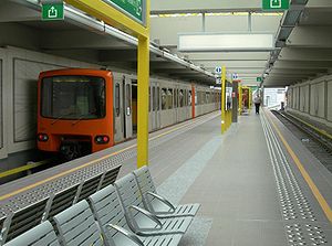
Delacroix metro station
 Delacroix metro station | |||||||||||||||
| General information | |||||||||||||||
| Location | Rue Léon Delacroix / Léon Delacroixstraat 1070 Anderlecht, Brussels-Capital Region, Belgium | ||||||||||||||
| Coordinates | 50°50′42″N 4°19′28″E / 50.84500°N 4.32444°E | ||||||||||||||
| Owned by | STIB/MIVB | ||||||||||||||
| Platforms | Island platform | ||||||||||||||
| Tracks | 2 | ||||||||||||||
| Construction | |||||||||||||||
| Structure type | Elevated | ||||||||||||||
| History | |||||||||||||||
| Opened | 4 September 2006 | ||||||||||||||
| Services | |||||||||||||||
| |||||||||||||||
Delacroix (French pronunciation: [dəlakʁwa]) is a Brussels Metro station on lines 2 and 6. It is located in the municipality of Anderlecht, in the western part of Brussels, Belgium. It is an elevated station, running parallel to the Rue Léon Delacroix/Léon Delacroixstraat, and forming a bridge-viaduct over the Brussels–Charleroi Canal, with entries and exits leading to and from both banks of the canal. The station takes its name from that nearby street, itself named after Léon Delacroix, Belgium's 22nd Prime Minister.
The metro station opened on 4 September 2006 as the southern terminus of line 2. On 4 April 2009, the "loop" of line 2 was completed with the junction between Delacroix and Gare de l'Ouest/Weststation. Following the reorganisation of the Brussels Metro on that occasion, it now lies on the joint section of lines 2 and 6.[1][2]

See also
[edit]References
[edit]- ^ "Line 2 direction SIMONIS - stib-mivb.be". www.stib-mivb.be. Retrieved 6 August 2024.
- ^ "Line 6 direction ROI BAUDOUIN - stib-mivb.be". www.stib-mivb.be. Retrieved 6 August 2024.
External links
[edit] Media related to Delacroix metro station, Brussels at Wikimedia Commons
- STIB/MIVB official website
