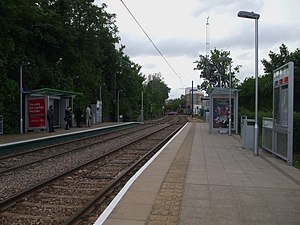
Merton Park tram stop
 | |
| General information | |
| Location | Merton Park, London Borough of Merton United Kingdom |
| Operated by | Tramlink |
| Platforms | 2 |
| Construction | |
| Accessible | Yes |
| Other information | |
| Fare zone | London fare zones 3, 4, 5 and 6 |
| History | |
| Opened | 2000 |
| Passengers | |
| 2009–10 | 0.327 million total boardings and alightings[1] |
| 2010–11 | |
Merton Park tram stop is a stop on the Tramlink service in the London Borough of Merton.
It overlaps part of the site of the former Merton Park railway station which was served by passenger trains on the West Croydon to Wimbledon Line until 1997, and by trains via Tooting Junction on the Merton Abbey Branch until 1929. The station building of the original station (about 200 yards south) has been converted to a private house.
Access is provided by footpath from Kingston Road at the site of the old level crossing and signal box. A footpath also comes from the nearby nature preserve at Nursery Road playing fields and another level crossing from a footpath from Dorset Road (B285).
Trams call at the stop every 5 minutes with trams scheduled to arrive at both platforms simultaneously.
Connections
London Buses routes 152; 163; and 164 serve the tram stop.
| Preceding station | Following station | |||
|---|---|---|---|---|
toward Template:Tramlink stations | Template:Tramlink lines | toward Template:Tramlink stations |
||
| Template:Tramlink lines | toward Template:Tramlink stations |
References
- ^ "Tram Stop Usage 2009-10 (FOI)" (XLS). Tramlink annual passenger performance 2009-2010. Transport for London. 18 August 2011. Retrieved 28 November 2012.
- ^ "Tramlink numbers 2010-2011" (PDF). Tramlink annual passenger performance 2010-2011. Transport for London. 28 March 2012. Retrieved 28 November 2012.
51°24′49″N 0°12′4″W / 51.41361°N 0.20111°W
